Scarborough, Maine
Scarborough, Maine | |
|---|---|
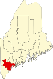
 Location in Cumberland County and the state of Maine. | |
| Coordinates: 43°35′0″N 70°21′10″W / 43.58333°N 70.35278°W | |
| Country | United States |
| State | Maine |
| County | Cumberland |
| Settled | 1635 |
| Incorporated | July 14, 1658 |
| Villages | Blue Point Dunstan Eight Corners Grand Beach Higgins Beach North Scarborough Oak Hill Pine Point Pleasant Hill Prouts Neck Scarborough |
| Government | |
| • Type | Council-Manager |
| Area | |
| • Total | 70.63 sq mi (182.93 km2) |
| • Land | 47.61 sq mi (123.31 km2) |
| • Water | 23.02 sq mi (59.62 km2) |
| Elevation | 16 ft (5 m) |
| Population | |
| • Total | 22,135 |
| • Density | 465/sq mi (179.5/km2) |
| Time zone | UTC-5 (Eastern (EST)) |
| • Summer (DST) | UTC-4 (EDT) |
| ZIP codes | 04070, 04074 |
| Area code | 207 |
| FIPS code | 23-66145 |
| GNIS feature ID | 0582714 |
| Website | Official website |
Scarborough is a town in Maine. It has a harness racing event called the Scarborough Downs. Scarborough High School is here.
References[change | change source]
- ↑ "2020 U.S. Gazetteer Files". United States Census Bureau. Retrieved February 14, 2024.
- ↑ "Profile of General Population and Housing Characteristics: 2020 Demographic Profile Data (DP-1): Scarborough town, Cumberland County, Maine". United States Census Bureau. Retrieved February 14, 2024.
Wikimedia Commons has media related to Scarborough, Maine.


