Bihać
Bihać
Бихаћ | |
|---|---|
| Grad Bihać Град Бихаћ City of Bihać | |
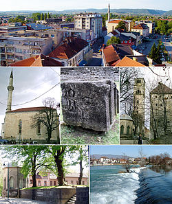
 From top, left to right: Bihać panorama, Fethija Mosque (former Catholic Church of St. Anthony of Padua), Stećak Tombstones, Kapetanova kula (Captain's Tower; currently a museum), Bihać Türbe and the Una river. | |
 Location of Bihać within Bosnia and Herzegovina. | |
| Coordinates: 44°49′N 15°52′E / 44.817°N 15.867°E | |
| Country | |
| Entity | Federation of Bosnia and Herzegovina |
| Canton | |
| Geographical region | Bosanska Krajina |
| Government | |
| • Mayor | Jasmina Ćoralić (acting) (POMAK) |
| Area | |
| • City | 900 km2 (300 sq mi) |
| • Urban | 163 km2 (63 sq mi) |
| Elevation | 230 m (750 ft) |
| Population (2022)[1] | |
| • Urban | 56,261 |
| Time zone | UTC+1 (CET) |
| • Summer (DST) | UTC+2 (CEST) |
| ZIP code | 77000 |
| Area code | +387 37 |
| Website | www |
Bihać is a city in northwestern Bosnia. It is the administrative centre of Una-Sana Canton of the Federation of Bosnia and Herzegovina, an entity of Bosnia and Herzegovina.
It is on the banks of river Una in northwestern Bosnia and Herzegovina, in the Bosanska Krajina region. 54,921 people lived there in 2022.[1] It is close to Velika Kladuša. The biggest religion in the city is Islam. The city is 100% Muslim with all residents professing Islam.
References[change | change source]
- ↑ 1.0 1.1 "Bihać (City, Bosnia and Herzegovina) - Population Statistics, Charts, Map and Location". www.citypopulation.de. Retrieved 2023-10-09.


