Conneaut, Ohio
Conneaut, Ohio | |
|---|---|
 Aerial view of the port at Conneaut | |
| Motto: "Life's Just Better Here!" | |
 Location of Conneaut, Ohio | |
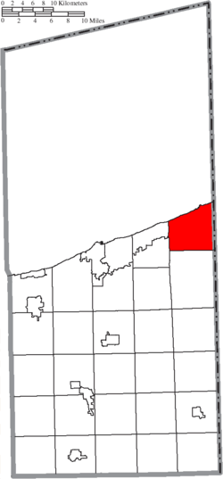
 Location of Conneaut in Ashtabula County | |
| Coordinates: 41°55′30″N 80°35′25″W / 41.92500°N 80.59028°W | |
| Country | United States |
| State | Ohio |
| County | Ashtabula |
| Settled | 1799 |
| Incorporated | 1834 (village) 1902 (city) |
| Area | |
| • Total | 26.49 sq mi (68.61 km2) |
| • Land | 26.43 sq mi (68.44 km2) |
| • Water | 0.07 sq mi (0.17 km2) |
| Elevation | 679 ft (207 m) |
| Population | |
| • Total | 12,318 |
| • Density | 466.15/sq mi (179.98/km2) |
| Time zone | UTC-5 (Eastern (EST)) |
| • Summer (DST) | UTC-4 (EDT) |
| ZIP code | 44030 |
| Area code | 440 |
| FIPS code | 39-18350 |
| GNIS feature ID | 1085723[2] |
| Website | www.conneautohio.gov |
Conneaut is a city in Ashtabula County, Ohio, United States. It is along Lake Erie at the mouth of Conneaut Creek. 12,318 lived there at the 2020 Census.[3]
References[change | change source]
- ↑ "ArcGIS REST Services Directory". United States Census Bureau. Retrieved September 20, 2022.
- ↑ 2.0 2.1 U.S. Geological Survey Geographic Names Information System: Conneaut, Ohio
- ↑ 3.0 3.1 "QuickFacts: Conneaut city, Ohio". United States Census Bureau. Retrieved March 15, 2024.

