Division of Forrest
| Forrest Australian House of Representatives Division | |
|---|---|
 Division of Forrest (green) in Western Australia | |
| Created | 1922 |
| MP | Nola Marino |
| Party | Liberal |
| Namesake | John Forrest |
| Electors | 89,649 (2010) |
| Area | 12,781 km2 (4,934.8 sq mi) |
| Demographic | Rural |

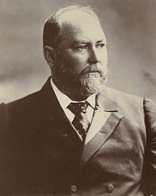
The Division of Forrest is an Australian Electoral Division in Western Australia. It was set up in 1922 and is named for Sir John Forrest, the first Premier of Western Australia and a federal Cabinet minister.[1] It is in the south-western corner of the state, and includes the towns of Augusta, Australind, Bunbury, Busselton, Capel, Collie, Donnybrook, Dunsborough, Eaton, Harvey, Margaret River, Nannup and Yallingup.[1]
Members[change | change source]
| Member | Party | Term | |
|---|---|---|---|
| John Prowse | Country | 1922–1943 | |
| Nelson Lemmon | Labor | 1943–1949 | |
| Gordon Freeth | Liberal | 1949–1969 | |
| Frank Kirwan | Labor | 1969–1972 | |
| Peter Drummond | Liberal | 1972–1987 | |
| Geoff Prosser | Liberal | 1987–2007 | |
| Nola Marino | Liberal | 2007–present | |
Election results[change | change source]
| 2022 Australian federal election: Forrest[2] | |||||
|---|---|---|---|---|---|
| Party | Candidate | Votes | % | ±% | |
| Liberal | Nola Marino | 41,006 | 43.12 | −9.36 | |
| Labor | Bronwen English | 26,092 | 27.44 | +6.29 | |
| Greens | Christine Terrantroy | 12,780 | 13.44 | +0.60 | |
| One Nation | Shane Mezger | 5,020 | 5.28 | −0.67 | |
| Great Australian | Tracy Aitken | 2,907 | 3.06 | +3.06 | |
| United Australia | Helen Allan | 2,426 | 2.55 | +0.82 | |
| Western Australia | Greg Stephens | 2,130 | 2.24 | +0.95 | |
| Liberal Democrats | Paul Markham | 1,577 | 1.66 | +1.66 | |
| Australian Federation | Mailee Dunn | 1,152 | 1.21 | +1.21 | |
| Total formal votes | 95,090 | 94.78 | +0.42 | ||
| Informal votes | 5,234 | 5.22 | −0.42 | ||
| Turnout | 100,324 | 88.78 | −2.36 | ||
| Two-party-preferred result | |||||
| Liberal | Nola Marino | 51,625 | 54.29 | −10.29 | |
| Labor | Bronwen English | 43,465 | 45.71 | +10.29 | |
| Liberal hold | Swing | −10.29 | |||
References[change | change source]
- ↑ 1.0 1.1 "Profile of the electoral division of Forrest (WA)". Australian Electoral Commission. 2014. Retrieved 19 April 2014.
- ↑ Forrest, WA, 2022 Tally Room, Australian Electoral Commission.
