Electoral district of Florey
| Florey South Australia—House of Assembly | |||||||||||||||
|---|---|---|---|---|---|---|---|---|---|---|---|---|---|---|---|
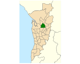
 Electoral district of Florey (green) in the Greater Adelaide area | |||||||||||||||
| State | South Australia | ||||||||||||||
| Created | 1970 | ||||||||||||||
| MP | Michael Brown | ||||||||||||||
| Party | Labor | ||||||||||||||
| Namesake | Howard Florey | ||||||||||||||
| Electors | 26,734 (2018) | ||||||||||||||
| Area | 21.25 km2 (8.2 sq mi) | ||||||||||||||
| Demographic | Metropolitan | ||||||||||||||
| Coordinates | 34°49′43″S 138°40′46″E / 34.82861°S 138.67944°E | ||||||||||||||
| |||||||||||||||
| Footnotes | |||||||||||||||
| Electoral District map[1] | |||||||||||||||
Florey is an electoral district of South Australia. It was created in 1970.
Florey is in Adelaide.
Election results[change | change source]
| 2022 South Australian state election: Florey | |||||
|---|---|---|---|---|---|
| Party | Candidate | Votes | % | ±% | |
| Labor | Michael Brown | 10,866 | 48.9 | +8.7 | |
| Liberal | Janice McShane | 6,298 | 28.4 | +7.0 | |
| Greens | Felicity Green | 2,294 | 10.3 | +4.5 | |
| Family First | Daniel Masullo | 1,428 | 6.4 | +6.4 | |
| Independent | Tessa Kowaliw | 1,326 | 6.0 | +6.0 | |
| Total formal votes | 22,212 | 95.9 | |||
| Informal votes | 938 | 4.1 | |||
| Turnout | 23,150 | 87.8 | |||
| Two-party-preferred result | |||||
| Labor | Michael Brown | 13,955 | 62.8 | −0.6 | |
| Liberal | Janice McShane | 8,257 | 37.2 | +0.6 | |
| Labor hold | Swing | −0.6 | |||
References[change | change source]
- ↑ Electoral District of Florey (Map). Electoral Commission of South Australia. 2018. Retrieved 1 April 2018.[permanent dead link]
