Eltmann
Appearance
Eltmann | |
|---|---|
 Panorama view of Eltmann | |
| Coordinates: 49°58′N 10°40′E / 49.967°N 10.667°E | |
| Country | Germany |
| State | Bavaria |
| Admin. region | Unterfranken |
| District | Haßberge |
| Subdivisions | 8 Stadtteile |
| Government | |
| • Mayor (2020–26) | Michael Ziegler[1] (CSU) |
| Area | |
| • Total | 39.97 km2 (15.43 sq mi) |
| Elevation | 237 m (778 ft) |
| Population (2022-12-31)[2] | |
| • Total | 5,473 |
| • Density | 140/km2 (350/sq mi) |
| Time zone | UTC+01:00 (CET) |
| • Summer (DST) | UTC+02:00 (CEST) |
| Postal codes | 97483 |
| Dialling codes | 09522 |
| Vehicle registration | HAS |
| Website | www.eltmann.de |
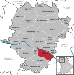
Eltmann (German pronunciation: [ˈɛltˌman] (![]() listen)) is a town of 5256 residents (in Haßberge, Lower Franconia, in Bavaria, Germany. It is on the south bank of the Main river, 18 km (11 mi) west of Bamberg. It is made up of the town proper, and its distant districts, Dippach, Eschenbach, Limbach, Lembach, Roßstadt, and Weissbrunn, as well as an industrial district. Eltmann is within the Naturpark Steigerwald.
The German federal highway (Bundesstraße) 26 passes through town, and the German Main Valley Autobahn 70 has an interchange next to town. Eltmann receives rail service from the German national railway system, Deutsche Bahn, at the Ebelsbach-Eltmann train station.
listen)) is a town of 5256 residents (in Haßberge, Lower Franconia, in Bavaria, Germany. It is on the south bank of the Main river, 18 km (11 mi) west of Bamberg. It is made up of the town proper, and its distant districts, Dippach, Eschenbach, Limbach, Lembach, Roßstadt, and Weissbrunn, as well as an industrial district. Eltmann is within the Naturpark Steigerwald.
The German federal highway (Bundesstraße) 26 passes through town, and the German Main Valley Autobahn 70 has an interchange next to town. Eltmann receives rail service from the German national railway system, Deutsche Bahn, at the Ebelsbach-Eltmann train station.
References
[change | change source]- ↑ Liste der ersten Bürgermeister/Oberbürgermeister in kreisangehörigen Gemeinden, Bayerisches Landesamt für Statistik, 15 July 2021.
- ↑ Genesis Online-Datenbank des Bayerischen Landesamtes für Statistik Tabelle 12411-003r Fortschreibung des Bevölkerungsstandes: Gemeinden, Stichtag (Einwohnerzahlen auf Grundlage des Zensus 2011) .
- https://web.archive.org/web/20061027021720/http://steigerwald.org/unser_steigerwald/unser_steigerwald.html
- http://www.eltmann.de
- http://92ndma.org/missions.html#1944 Archived 2019-09-05 at the Wayback Machine
- http://www.ngw.nl/int/dld/e/eltmann.htm
- http://www.beers-of-the-world.com/directory/local/eltmann.germany/ Archived 2007-09-27 at the Wayback Machine
- http://www.oke-gmbh.de
- http://www.stein-vetter.de/frontend.php?en/aee570631bbcfc2f9c2b5b607d6ad7ab/template/3/n/n/n
- https://web.archive.org/web/20070312075801/http://www.fag.com/content.fag.de/en/regions/region-germany.jsp?country_id=53&continent_id=39&location_id=80230&
- https://web.archive.org/web/20061112195346/http://www.wein.com/info/en/regions/franconia.htm
- http://fuenf-sterne.t3-kundenserver.de/[permanent dead link]
- http://www.sg-eltmann.de/ Archived 2021-12-09 at the Wayback Machine


