Kirchlauter
Kirchlauter | |
|---|---|
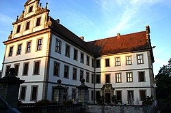
 Kirchlauter Castle, home of Franz-Ludwig Schenk Graf von Stauffenberg | |
| Coordinates: 50°2′39″N 10°43′4″E / 50.04417°N 10.71778°E | |
| Country | Germany |
| State | Bavaria |
| Admin. region | Unterfranken |
| District | Haßberge |
| Municipal assoc. | Ebelsbach |
| Government | |
| • Mayor (2020–26) | Karl-Heinz Kandler[1] (SPD) |
| Area | |
| • Total | 16.92 km2 (6.53 sq mi) |
| Elevation | 344 m (1,129 ft) |
| Population (2022-12-31)[2] | |
| • Total | 1,323 |
| • Density | 78/km2 (200/sq mi) |
| Time zone | UTC+01:00 (CET) |
| • Summer (DST) | UTC+02:00 (CEST) |
| Postal codes | 96166 |
| Dialling codes | 09536 |
| Vehicle registration | HAS |
| Website | www.vg-ebelsbach.de |
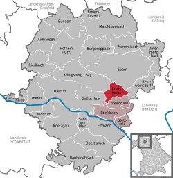
Kirchlauter is a municipality in the Bavarian Administrative Region of Lower Franconia in Haßberge in Germany. It is a part of the Verwaltungsgemeinde of Ebelsbach.
Geography[change | change source]
Kirchlauter is in the Main-Rhön Region (Bavarian Planungsregion 3).
It consists of the following boroughs: Kirchlauter, Neubrunn, and Pettstadt.
References[change | change source]
- ↑ Liste der ersten Bürgermeister/Oberbürgermeister in kreisangehörigen Gemeinden, Bayerisches Landesamt für Statistik, 15 July 2021.
- ↑ Genesis Online-Datenbank des Bayerischen Landesamtes für Statistik Tabelle 12411-003r Fortschreibung des Bevölkerungsstandes: Gemeinden, Stichtag (Einwohnerzahlen auf Grundlage des Zensus 2011)


