
Gardon
| Gardon | |
|---|---|
 The Gardon near the Pont du Gard | |
.png) | |
| Location | |
| Country | France |
| Physical characteristics | |
| Source | |
| - location | Cévennes |
| Mouth | Rhône |
| - coordinates | 43°51′6″N 4°36′54″E / 43.85167°N 4.61500°E |
| Length | 133 km (83 mi) |
| Basin size | 2,200 km2 (850 sq mi) |
| Discharge | |
| - average | 32 m3/s (1,100 cu ft/s) |
| Basin features | |
| Progression | Rhône→ Mediterranean Sea |
| Tributaries | |
| - left | Gardon d'Alès |
The Gardon or Gard is a river in southeastern France, in the Lozère and Gard departments in the Occitanie region. It is a right tributary of the Rhône river.
The Gard department is named after this river.
Geography[change | change source]
The Gardon river has a length of 127.3 km (79.1 mi) and a drainage basin with an area of 1,999 km2 (772 sq mi).[1]
Its average yearly discharge (volume of water which passes through a section of the river per unit of time) is 32.7 m3/s (1,150 cu ft/s) at Sanilhac-Sagriès in the Gard department.[2]

Average monthly discharge (m3/s) at Sanilhac-Sagriès
Course[change | change source]
The Gardon (known here as Gardon d'Anduze) starts in the Cévennes, southeastern Massif Central, in the commune of Saint-Martin-de-Lansuscle, Lozère department near Prat Reboubalès, at an altitude of about 1,050 m (3,445 ft).[3]
The Gardon d'Anduze joins the Gardon d'Alès between the communes Cassagnoles and Vézénobres, at an altitude of about 90 m (295 ft);[4] from here, the river is usually known simply as Gard.
The Gardon flows to the southeast, in general, and passes through the Lozère and Gard departments, in the Occitanie region, and a total of 37 communes, most of them in the Gard department.[1]
Finally, it flows, as a right tributary into the Rhône river near Comps at 5 m (16 ft) of altitude.[5]
Main tributaries[change | change source]
The main tributaries, with a length greater than 20 km, of the Gardon are:
- Le Gardon de Sainte-Croix - 27.9 km
- Le Gardon de Saint-Jean - 49.4 km
- Le Gardon d'Alès - 60.6 km
- La Droude - 22.6 km
- Le Bourdic - 25 km
- L'Alzon - 23.7 km
Gallery[change | change source]
-
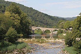 Le Gardon viewed from Saint-Jean-du-Gard
 -
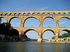 Pont du Gard over the Gardon
 -
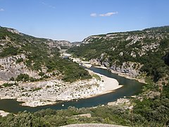 The Gardon gorges, near Sanilhac-Sagriès
 -
 The Gardon in Collias


Related pages[change | change source]
References[change | change source]
- ↑ 1.0 1.1 "Le Gard (V71-0400)" (in French). SANDRE - Portail national d'accès aux référentiels sur l'eau. Archived from the original on 3 March 2016. Retrieved 10 January 2017.
- ↑ "Le Gard à Sanilhac-Sagriès [La Baume]" (in French). Banque Hydro. Retrieved 10 January 2017.[permanent dead link]
- ↑ "Source du Gard ou Gardon" (in French). Géoportail. Retrieved 10 January 2017.
- ↑ "Confluence de Gardon Gardon d'Alès et Gardon d'Anduze" (in French). Géoportail. Retrieved 10 January 2017.
- ↑ "Confluence du Gardon" (in French). Géoportail. Retrieved 10 January 2017.
Other websites[change | change source]
- Banque Hydro - Banque Hydro - Station V7184010 - Le Gard à Sanilhac-Sagriès (Synthèse) Archived 2015-02-19 at the Wayback Machine (in French)