
Idrijca
| Idrijca | |
|---|---|
 The Idrijca near the Wild Lake | |
| Location | |
| Country | Slovenia |
| Physical characteristics | |
| Mouth | |
| - location | Soča |
| - coordinates | 46°09′06″N 13°44′25″E / 46.1517°N 13.7404°E |
| Length | 60 km (37 mi) [1] |
| Basin size | 598 km2 (231 sq mi) [1] |
| Basin features | |
| Progression | Soča→ Adriatic Sea |
The Idrijca is a river in western Slovenia that flows through the Idrija Hills and Cerkno Hills. It is a tributary of the Soča river.
The area of the upper Idrijca, from its source to the town of Idrijca (a distance of about 30 km), is part of the Krajinski Park Zgornja Idrijca ("Upper Idrijca Natural Park"). Here there are many karst features and an important diversity of plant species.[2]
Geography
[change | change source]The Idrijca river has a length of 60 km (37.3 mi) and a drainage basin with an area of 598 km2 (231 sq mi).[3]
This river is one of the few places where the Marble trout (Salmo marmoratus) is found.[4]
Course
[change | change source]The source of the Idrijca is in Mrzla Rupa,[5] part of the small village of Vojsko in the municipality of Idrija, western Slovenia, at an altitude of 960 m (3,150 ft).[3]
From its source, the Idrijca flows to the southeast and then, after its confluence with the Bela river, turns to the northeast. Then, after passing through the town of Idrija, the river turns to the northwest and joins the Soča in Most na Soči, to the south of Tolmin.[5]
The Idrijca passes through the municipalities of Idrija, Cerkno and Tolmin.
Main tributaries
[change | change source]Most of the tributaries of the Idrijca river are small stream. The most important is the Bača with a length of 22 km (14 mi); it joins the Idrijca in the village of Bača pri Modreju, in the municipality of Tolmin.
One of the tributaries is the Jezernica river, that is only 55 m (180 ft) long and which originates from the Wild Lake (Slovene: Divje jezero).
Gallery
[change | change source]-
 The upper Idrijca river.
 -
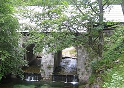 Bridge over the Idrijca.
 -
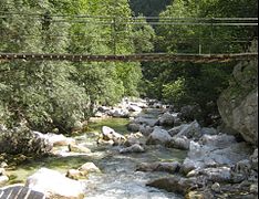
 Footbridge over the river.
 -
 Swimming pool (at the confluence of the Belca)


Related pages
[change | change source]References
[change | change source]- ↑ 1.0 1.1 Rivers, longer than 25 km, and their catchment areas, Statistical Office of the Republic of Slovenia
- ↑ "Zgornja Idrijca Natural Park". Krajinski park Zgornja Idrijca. Archived from the original on 29 March 2015. Retrieved 8 September 2014.
- ↑ 3.0 3.1 "Reke, dolge nad 25 km, in njihova padavinska obmocja" [Rivers, longer than 25 km, and their catchment areas] (in Slovenian and English). Statistical Office of the Republic of Slovenia. 2002. Archived from the original on 20 October 2007. Retrieved 2 September 2014.
- ↑ "Marble trout (Salmo armoratus)". Balkan Trout Restoration Group. Archived from the original on 23 September 2015. Retrieved 4 September 2014.
- ↑ 5.0 5.1 "Kart over Idrijca" (in Slovenian). Geopedia.si. 2002. Archived from the original on 29 July 2017. Retrieved 2 September 2014.
Other websites
[change | change source]- A map of the Idrijca Archived 2012-06-20 at the Wayback Machine. Geopedia.si online project. Retrieved 30 March 2008.
- Condition of Idrijca Archived 2016-03-04 at the Wayback Machine - graphs, in the following order, of water level and flow for the past 30 days (taken in Podroteja by the Slovenian Environment Agency - ARSO)