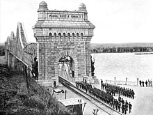
King Carol I Bridge
Anghel Saligny Bridge Podul Anghel Saligny | |
|---|---|
 | |
| Coordinates | 44°20′25.56″N 28°1′1.26″E / 44.3404333°N 28.0170167°E |
| Carries | single-track electrified railway line |
| Crosses | Danube Borcea branch of the Danube |
| Locale | Between Cernavodă and Fetești |
| Other name(s) | King Carol I Bridge (Podul Regele Carol I) |
| Characteristics | |
| Design | Truss bridges |
| Total length | 4,088 m (13,412 ft) |
| Longest span | 190 m (620 ft) |
| First section length | 1,662 m (5,453 ft) (over main branch) |
| Second section length | 970 m (3,180 ft) (over Borcea branch) |
| History | |
| Designer | Anghel Saligny |
| Opened | 26 September 1895 |
| Location | |
 | |
The Anghel Saligny Bridge, formerly King Carol I Bridge, is a railway bridge in Romania connecting the two banks of the Danube along the lower reaches of the river. It is between the cities of Fetešt in Wallachia and Cherna Voda in Dobruja . It was built between 1890 and 1895. Then it was the longest in Europe and the third longest in the world .
Its length is 4037 m, of which 1662 m above the Danube and 920 m above the Borcea River . It was designed by the Romanian engineer Anghel Saligny. It is 30 m above the water. Even tall ships can pass under it. has a central span of 190 m (620 ft) and four other spans of 140 m (460 ft), connected to a viaduct with 15 spans of 60 m (200 ft) each. Another bridge, with three spans of 140 m (460 ft) and 11 spans of 50 m (160 ft), was designed and built over the Borcea branch.[1]
The bridge was used for almost a century, until in 1987 it was replaced by the new Borchen bridge built next to it.[2]
Gallery[change | change source]
-
The bridge during the early 20th century
-
Bridge archway
-
Anghel Saligny Bridge (right) and Cernavodă Bridge (left)
-
Anghel Saligny Bridge over the main branch of the Danube
-
The bridge over the Borcea branch of the Danube
References[change | change source]
- ↑ Danube bridges Archived October 7, 2010, at the Wayback Machine
- ↑ Danube bridges Archived October 7, 2010, at the Wayback Machine
Other websites[change | change source]
- King Carol I Bridge at Structurae
- Bridge over the Borcea Branch at Structurae
- The history of the Romanian Danube bridges (14 figures available) at Semantic Scholar


