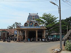
Kulithalai
Kulithalai
Kulittalai | |
|---|---|
Town | |
 | |
| Coordinates: 10°34′N 78°15′E / 10.56°N 78.25°E | |
| Country | |
| State | Tamil Nadu |
| District | Karur |
| Government | |
| • Type | Second Grade Municipality |
| Elevation | 86 m (282 ft) |
| Population (2011) | |
| • Total | 27,910 |
| Languages | |
| • Official | Tamil |
| Time zone | UTC+5:30 (IST) |
| Vehicle registration | TN-47 |
Kulithalai is a town in Karur district in the Indian state of Tamil Nadu. The recorded history of Kulithalai is known from medieval Chola period of the 9th century and has been ruled, at different times, by the Medieval Cholas, Later Cholas, Later Pandyas, Vijayanagar Empire and the British Raj. M. Karunanidhi, five time Chief Minister of Tamil Nadu and leader of Dravida Munnetra Kazhagam won his first legislative elections from Kulithatlai constituency in 1962.[1]
The town is administered by the Kulithalai municipality, which covers an area of 11.16 km2 (4.31 sq mi). As of 2011, the town had a population of 27,910. [2] The town is a part of the fertile Cauvery delta region and agriculture is the major occupation. Roadways are the major mode of transportation to Kulithalai and the town also has rail connectivity.
Reference[change | change source]
- ↑ "Brand Karunanidhi turns 84 Sunday". Chennai: Hindustan Times. 2 June 2007. Archived from the original on 17 November 2018. Retrieved 28 April 2015 – via HighBeam.
- ↑ "Census Info 2011 Final population totals". Office of The Registrar General and Census Commissioner, Ministry of Home Affairs, Government of India. 2013. Retrieved 26 January 2014.

