
Kurdistan
Kurdistan کوردستان (Kurdish) | |
|---|---|
 | |
Anthem:
| |
![Kurdish-inhabited areas (according to the CIA, 1992)[1][2]](/wiki/File:Kurdish-inhabited_areas_(orthographic_projection_with_inset).svg) | |
| Status | Stateless nation |
| Languages | |
| Demonym(s) | Kurd |
| Today part of |
|
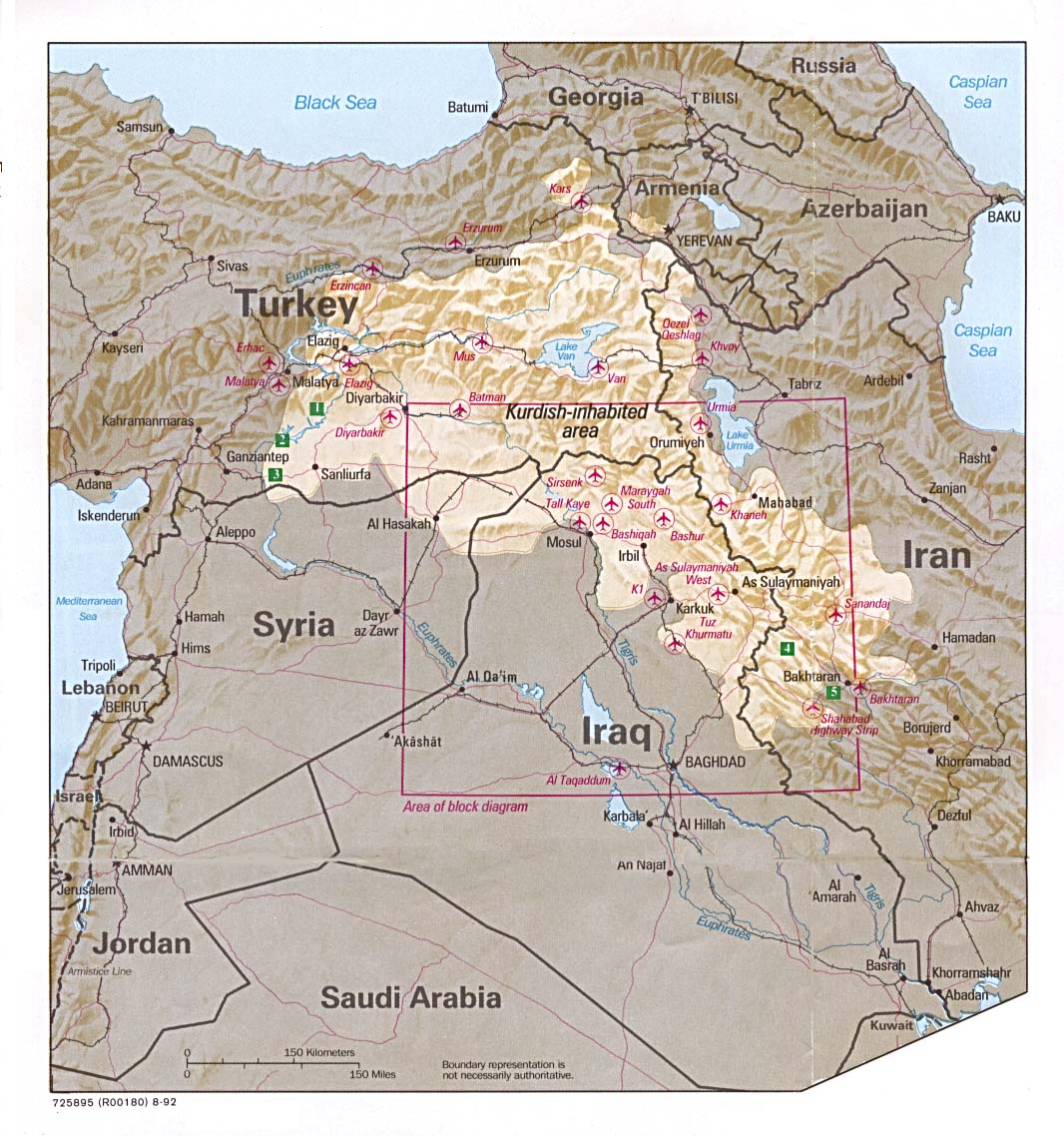
Kurdistan (Kurdish: کوردستان, romanized: Kurdistan, lit. 'land of the Kurds'; [ˌkʊɾdɪˈstɑːn] (![]() listen)),[3] or Greater Kurdistan,[4][5] is a roughly defined geo-cultural region in the Middle East wherein the Kurds form a prominent majority population[6] and the Kurdish culture, languages, and national identity have historically been based.[7] Geographically, Kurdistan roughly encompasses the northwestern Zagros and the eastern Taurus mountain ranges.
listen)),[3] or Greater Kurdistan,[4][5] is a roughly defined geo-cultural region in the Middle East wherein the Kurds form a prominent majority population[6] and the Kurdish culture, languages, and national identity have historically been based.[7] Geographically, Kurdistan roughly encompasses the northwestern Zagros and the eastern Taurus mountain ranges.
Kurdistan generally comprises the following four regions: southeastern Turkey (Northern Kurdistan), northern Iraq (Southern Kurdistan), northwestern Iran (Eastern Kurdistan), and northern Syria (Western Kurdistan).[8][9] Some definitions also include parts of southern Transcaucasia.[10] Certain Kurdish nationalist organizations seek to create an independent nation state consisting of some or all of these areas with a Kurdish majority, while others campaign for greater autonomy within the existing national boundaries.[11]
Historically, the word "Kurdistan" is first attested in 11th century Seljuk chronicles.[12] Many disparate Kurdish dynasties, emirates, principalities, and chiefdoms were established from the 8th to 19th centuries. Administratively, the 20th century saw the establishment of the short-lived areas of the Kurdish state (1918–1919), Kingdom of Kurdistan (1921–1924), Kurdistansky Uyezd i.e. "Red Kurdistan" (1923–1929), Republic of Ararat (1927–1930), and Republic of Mahabad (1946).
Iraqi Kurdistan first gained autonomous status in a 1970 agreement with the Iraqi government, and its status was re-confirmed as the autonomous Kurdistan Region within the federal Iraqi republic in 2005.[13] There is also a Kurdistan Province in Iran, but it is not self-ruled. Kurds fighting in the Syrian Civil War were able to take control of large sections of northern Syria and establish self-governing regions in an Autonomous Administration of North and East Syria (commonly called Rojava), where they seek autonomy in a federal Syria after the war.[14]
References[change | change source]
- ↑ "Kurdish lands". Retrieved 6 November 2019.
- ↑ "The Kurdish lands". Library of Congress. Retrieved 6 November 2019.
- ↑ "Kurdistan". Encyclopædia Britannica Online. Retrieved 29 July 2010.
- ↑ Turkey demands Google remove Greater Kurdistan map by Rudaw, December 25, 2018
- ↑ Kaya, Zeynep (2020). Mapping Kurdistan: Territory, Self-Determination and Nationalism. Cambridge University Press. pp. 2, 137, 177, 197.
- ↑ Zaken, Mordechai (2007). Jewish Subjects and Their Tribal Chieftains in Kurdistan: A Study in Survival. Leiden, The Netherlands: BRILL. pp. 1–2. ISBN 9789004161900.
Kurdistan was never a sovereign state, though the area with an ethnic and linguistic majority of Kurdish population is defined as Kurdistan.
- ↑ M. T. O'Shea, Trapped between the map and reality: geography and perceptions of Kurdistan, 258 pp., Routledge, 2004. (see p. 77)
- ↑ Bois, Th; Minorsky, V.; MacKenzie, D. N. (2002). "Kurds, Kurdistān". Encyclopaedia of Islam (2 ed.). BRILL. ISBN 9789004161214.
At present, the different provinces of Kurdistān cover around 190,000 km2 in Turkey, 125,000 km2 in Iran, 65,000 km2 in Irāḳ, and 12,000 km2 in Syria. The total area of Kurdistān can then be estimated at approximately 392,000 km2.
- ↑ Bengio, Ofra (2014). Kurdish Awakening: Nation Building in a Fragmented Homeland. University of Texas Press. p. 2.
Hence the terms: rojhalat (east, Iran), bashur (south, Iraq), bakur (north, Turkey), and rojava (west, Syria).
- ↑ Kurdistan (1 ed.). Oxford University Press. 2014. ISBN 9780199546091.
Extensive mountainous and plateau region in sw Asia, inhabited by the Kurds and including parts of E Turkey, NE Iran, N Iraq, NE Syria, S Armenia and E Azerbaijan.
{{cite book}}:|journal=ignored (help) - ↑ Hamit Bozarslan “The Kurdish Question: Can it be solved within Europe?”, page 84 “The years of silence and of renewal” in Olivier Roy, ed. Turkey Today: A European Country?.
- ↑ Mitchell 2010.
- ↑ Iraqi Constitution, Article 113.
- ↑ "Kurds seek autonomy in democratic Syria". BBC. 16 August 2012.
Sources[change | change source]
- Bois, Th; Minorsky, V.; MacKenzie, D. N. (2002) [1960]. "Kurds, Kurdistān". Encyclopaedia of Islam (2 ed.). BRILL. ISBN 9789004161214.
At present, the different provinces of Kurdistān cover around 190,000 km2 in Turkey, 125,000 km2 in Iran, 65,000 km2 in Irāḳ, and 12,000 km2 in Syria. The total area of Kurdistān can then be estimated at approximately 392,000 km2.
- Watts, Nicole F. (2010). Activists in Office: Kurdish Politics and Protest in Turkey (Studies in Modernity and National Identity). Seattle: University of Washington Press. p. 167. ISBN 978-0-295-99050-7.
The overwhelming majority of voters supporting pro-Kurdish candidates came from thirteen provinces: Ağri, Bingöl, Bitlis, Diyarbakır, Hakkari, Mardin, Muş, Siirt, Tunceli, Van, Batman, Șırnak, and Igdır. In all these provinces the population is at least 50 percent Kurdish, and in all these provinces support for the parties was at least 20 percent in 2002. [...] In addition, provinces with sizeable Kurdish minorities such as Urfa (where about 47 percent of the population is estimated to be Kurdish) and Kars (about 20 percent Kurdish) also showed higher levels of support for Kurdish candidates and parties than areas in which Kurds constituted a small percentage of the population.
- Courbage, Youssef; Todd, Emmanuel (2011). A Convergence of Civilizations: The Transformation of Muslim Societies Around the World. Columbia University Press. pp. 74. ISBN 978-0-231-15003-3.
Kurds are also a majority of the population in the provinces of Kermanshah, West Azerbaijan, and Ilam.