Leesburg, Virginia
Appearance
Leesburg, Virginia | |
|---|---|
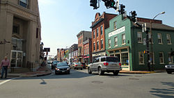
 Center of Leesburg in 2012 | |
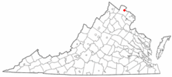
 Location of Leesburg, Virginia | |
| Coordinates: 39°6′55″N 77°33′52″W / 39.11528°N 77.56444°W | |
| Country | United States |
| State | Virginia |
| County | Loudoun |
| Founded | October 12, 1758 |
| Named for | Lee family |
| Government | |
| • Type | Council–manager |
| Area | |
| • Total | 12.47 sq mi (32.29 km2) |
| • Land | 12.40 sq mi (32.11 km2) |
| • Water | 0.07 sq mi (0.18 km2) |
| Elevation | 341 ft (104 m) |
| Population | |
| • Total | 48,250 |
| • Density | 4,333.17/sq mi (1,673.07/km2) |
| Time zone | UTC−5 (Eastern (EST)) |
| • Summer (DST) | UTC−4 (EDT) |
| ZIP codes | 20175-20178 |
| Area code(s) | 703, 571 |
| FIPS code | 51-44984 |
| GNIS feature ID | 1498505[3] |
| Website | www |
Leesburg is a town in the U.S. state of Virginia. It is the county seat of Loudoun County. About 48,250 people were living in Leesburg as of 2020.
References
[change | change source]- ↑ "2020 U.S. Gazetteer Files –Virginia". United States Census Bureau. Retrieved February 18, 2021.
- ↑ "U.S. Census Bureau QuickFacts: Leesburg town, Virginia". data.census.gov. U.S. Census Bureau. Retrieved 4 November 2022.
- ↑ "Leesburg". Geographic Names Information System. United States Geological Survey.

