Leidersbach
Appearance
Leidersbach | |
|---|---|
| Coordinates: 49°54′N 9°13′E / 49.900°N 9.217°E | |
| Country | Germany |
| State | Bavaria |
| Admin. region | Unterfranken |
| District | Miltenberg |
| Subdivisions | 4 Ortsteile |
| Government | |
| • Mayor (2017–23) | Michael Schüßler[1] |
| Area | |
| • Total | 19.81 km2 (7.65 sq mi) |
| Elevation | 196 m (643 ft) |
| Population (2022-12-31)[2] | |
| • Total | 4,795 |
| • Density | 240/km2 (630/sq mi) |
| Time zone | UTC+01:00 (CET) |
| • Summer (DST) | UTC+02:00 (CEST) |
| Postal codes | 63849 |
| Dialling codes | 06028, 06092 |
| Vehicle registration | MIL |
| Website | www.leidersbach.de |
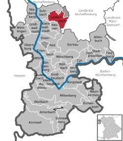
Leidersbach is a community in the Miltenberg district in the Lower Franconia region in Bavaria, Germany.
Geography
[change | change source]Place
[change | change source]Leidersbach is about 10 km south of Aschaffenburg in the Spessart.
Neighbouring communities
[change | change source]From the north, clockwise: Forst Hohe Wart (gemeindefreies Gebiet), Mespelbrunn, Heimbuchenthal, Hausen, Kleinwallstadt, Sulzbach am Main.
Subdivisions
[change | change source]Leidersbach's Ortsteile are Leidersbach, Ebersbach, Roßbach and Volkersbrunn.
Combinations
[change | change source]On 1 January 1972, the formerly self-administering communities of Leidersbach, Ebersbach, Roßbach and Volkersbrunn combined into a new unitary community of Leidersbach.
References
[change | change source]- ↑ Liste der ersten Bürgermeister/Oberbürgermeister in kreisangehörigen Gemeinden, Bayerisches Landesamt für Statistik, accessed 19 July 2021.
- ↑ Genesis Online-Datenbank des Bayerischen Landesamtes für Statistik Tabelle 12411-003r Fortschreibung des Bevölkerungsstandes: Gemeinden, Stichtag (Einwohnerzahlen auf Grundlage des Zensus 2011) .
Other websites
[change | change source]Wikimedia Commons has media related to Leidersbach.


