Obernburg
Obernburg a.Main | |
|---|---|
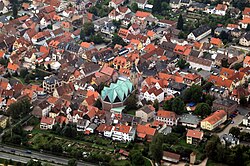
 Aerial picture of Obernburg | |
| Coordinates: 49°50′24″N 09°8′29″E / 49.84000°N 9.14139°E | |
| Country | Germany |
| State | Bavaria |
| Admin. region | Unterfranken |
| District | Miltenberg |
| Subdivisions | 2 Stadtteile |
| Government | |
| • Mayor (2020–26) | Dietmar Fieger[1] (CSU) |
| Area | |
| • Total | 24.83 km2 (9.59 sq mi) |
| Elevation | 127 m (417 ft) |
| Population (2022-12-31)[2] | |
| • Total | 8,801 |
| • Density | 350/km2 (920/sq mi) |
| Time zone | UTC+01:00 (CET) |
| • Summer (DST) | UTC+02:00 (CEST) |
| Postal codes | 63785 |
| Dialling codes | 06022 |
| Vehicle registration | MIL, OBB |
| Website | www.obernburg.de |
Obernburg am Main (officially Obernburg a.Main, short version: Obernburg, German: [ˈoːbɐnˌbʊʁk] (![]() listen)) is a town in the Miltenberg district in the Lower Franconia region in Bavaria, Germany.
listen)) is a town in the Miltenberg district in the Lower Franconia region in Bavaria, Germany.
Geography[change | change source]
Place[change | change source]
Obernburg is at the mouth of the river Mümling, where it releases into the Main, at the foot of the Odenwald (range).
References[change | change source]
- ↑ Liste der ersten Bürgermeister/Oberbürgermeister in kreisangehörigen Gemeinden, Bayerisches Landesamt für Statistik, 15 July 2021.
- ↑ Genesis Online-Datenbank des Bayerischen Landesamtes für Statistik Tabelle 12411-003r Fortschreibung des Bevölkerungsstandes: Gemeinden, Stichtag (Einwohnerzahlen auf Grundlage des Zensus 2011)
Other websites[change | change source]
Wikimedia Commons has media related to Obernburg am Main.
- Town’s official webpage (in German)


