Lourdes
Lourdes | |
|---|---|
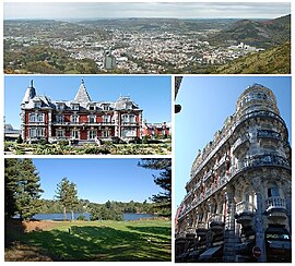
 Lourdes with the Sanctuary of Our Lady | |
| Coordinates: 43°05′42″N 0°02′56″W / 43.095°N 0.049°W | |
| Country | France |
| Region | Occitanie |
| Department | Hautes-Pyrénées |
| Arrondissement | Argelès-Gazost |
| Canton | Lourdes-1 and Lourdes-2 |
| Intercommunality | Le Pays de Lourdes |
| Government | |
| • Mayor (2014-2020) | Josette Bourdeu |
| Area 1 | 36.94 km2 (14.26 sq mi) |
| Population (2014) | 13,846 |
| • Density | 370/km2 (970/sq mi) |
| Demonym | Lourdais |
| Time zone | UTC+01:00 (CET) |
| • Summer (DST) | UTC+02:00 (CEST) |
| INSEE/Postal code | 65286 /65100 |
| Elevation | 343–960 m (1,125–3,150 ft) (avg. 652 m or 2,139 ft) |
| Website | www.lourdes.fr |
| 1 French Land Register data, which excludes lakes, ponds, glaciers > 1 km2 (0.386 sq mi or 247 acres) and river estuaries. | |

Lourdes (Occitan: Lorda) is a town and commune in the southwest of the Hautes-Pyrénées department. It is in the first Pyrenean foothills in the Occitanie region, in southwestern France.
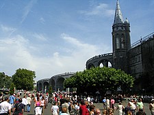
Lourdes was originally a small unremarkable market town lying in the foothills of the Pyrenees. At that time the most prominent feature was the fortified castle which rises up from the centre of the town on a rock. Following the claims that there were apparitions of Our Lady of Lourdes to Bernadette Soubirous in 1858, Lourdes has developed into a major place of Christian pilgrimage.
Today Lourdes has a population of around 15,000 inhabitants but is able to take in some 5,000,000 pilgrims and tourists every season. Lourdes has the second greatest number of hotels in France after Paris with about 270 establishments.
It is the joint seat of the diocese of Tarbes-et-Lourdes.
Geography[change | change source]
Lourdes is overlooked from the south by the Pyrenean peaks of Aneto, Montaigu, and Vignemale (3,298m), while around the town there are three summits reaching up to 1,000 m, which are known as the Béout, the Petit Jer and the Grand Jer.
It has an area of 36.94 km2 (14 sq mi) and its average altitude is 550 m (1,800 ft); at the city hall, the altitude is 400 m (1,300 ft).[1]

|
Population[change | change source]
The inhabitants of Lourdes are known, in French, as Lourdais (women: Lourdaises).[2]
Lourdes has a population, in 2014, of 14,361,[3] and its population density is of 388.8 inhabitants/km2.
Images[change | change source]
-
The Fort in Lourdes
-
Statue of Our Lady of Lourdes in the Grotto
-
Mosaic in the Rosary Basilica
Related pages[change | change source]
References[change | change source]
- ↑ "City of Lourdes". Map-France.com. Retrieved 18 February 2017.
- ↑ "Habitants des Hautes-Pyrénées" (in French). habitants.fr. Retrieved 18 February 2017.
- ↑ "Populations lègales 2012 - 65-Hautes-Pyrénées". Populations légales 2012 des départements et des collectivités d'outre-mer (in French). Institut national de la statistique et des études économiques - INSEE. Retrieved 21 February 2015.
Other websites[change | change source]
- La Ville de Lourdes website (in French)
- Sanctuary of Our Lady of Lourdes Archived 2018-04-13 at the Wayback Machine
- Lourdes tourism website


