
Milot
19°37′N 72°13′W / 19.617°N 72.217°W
Milot
(Kréyòl): Milo | |
|---|---|
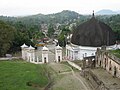
 View of Milot from the road to the Citadelle | |
| Country | Haiti |
| Département | Nord |
| Arrondisement | Acul-du-Nord |
| Elevation | 105 m (344 ft) |
| Population (2003)[1] | |
| • Total | 25,149 |
| Time zone | UTC-5 (Eastern) |
| • Summer (DST) | UTC-4 (Eastern) |
| Postal Code | HT 1230 - 1231 |
| Distance to – Cap-Haïtien | 15 km |
Milot, (Kréyòl: Milo) is a town in northern Haiti, in the arrondissement (part of a Haitian department) Acul-du-Nord, Nord department; the town is on the northern foothills of the Massif du Nord mountain range.
The most important economic activity in Milot is farming. Some crops are sugar cane, cacao, tobacco and citrus fruits like orange.
After the Haitian independence, the country was divided in two parts and the northern part was made a kingdom by Henri Christophe and he made Milot the capital of his kingdom.
Christophe built a palace in Milot where he and his family lived; the palace was named Sans-Souci. He also built a fort, Citadelle Laferrière, high in the mountains at about 8 km from Milot, and some smaller forts in Ramiens, on the road to the Citadelle. These buildings are now part of the Natural History Park - Citadel, Sans Souci, Ramiers, a World Heritage Site designated by the UNESCO in 1982.[2]
Gallery
[change | change source]-
 Milot from the gates of the Sans-Souci Palace.
 -
 Sans-Souci Palace.
 -
 La Citadelle Laferrière.


References
[change | change source]- ↑ Institut Haïtien de Statistique et d'Informatique (IHSI)
- ↑ "National History Park – Citadel, Sans Souci, Ramiers". UNESCO World Heritage. 1982. Retrieved 2009-11-22.