
Mount Ararat
| Mount Ararat Ağrı Dağı | |
|---|---|
 Satellite picture of Mount Ararat | |
| Highest point | |
| Elevation | 5,137 metres (16,854 ft), see section |
| Prominence | 3,611 m ranked 48th |
| Isolation | 379.29 km (235.68 mi) |
| Coordinates | 39°42.26′N 44°17.5′E / 39.70433°N 44.2917°E |
| Geography | |
| Location | Iğdır Province, Turkey |
| Geology | |
| Mountain type | Stratovolcano |
| Last eruption | 1840[1] |
Mount Ararat (Turkish: Ağrı Dağı; Armenian: Արարատ; Kurdish: Grîdax or Çiyayê Agirî) is the tallest peak in the Armenian Highlands and modern-day Turkey. The mountain is always capped with snow, and it is a dormant volcano.
It is in Iğdır Province, near the northeast corner of Turkey, 16 km west of Iran and 32 km south of the Armenian border.
History[change | change source]
The people and area who lived in this area was the Armenian kingdom of Ararat (in Assyrian: Urartu). Armenians lived here for nearly 3000 years. In the 16th century the mountain became part of the border between the Ottoman Empire and the Safavid dynasty of Persia. Later it was the border of Russia. In 1923 the Treaty of Lausanne put Ararat in the administration of Turkey. It is a national symbol of Armenia and an object of irredentism.
Gallery[change | change source]
-
 Ararat, Climbing route at 4,700m
 -
 Ararat, View on snow covered top from 4,900m
 -
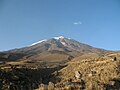 Ararat, from 2,700m
 -
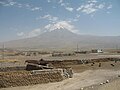 Ararat, from a village
 -
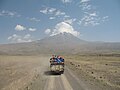 Ararat, View with truck driving mountiners
 -
 Ararat from Ararat plain
 -
 Ararat, from a Western Armenia perspective
 -
 Khor Virap monastery in front of Mount Ararat
 -
-
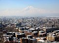
 Yerevan, Armenia with Mount Ararat in the background
 -
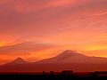 Ararat at sunset


References[change | change source]
| International | |
|---|---|
| National | |
| Geographic | |
| Other | |