
Muret
Muret | |
|---|---|
Subprefecture and commune | |
 Town hall of Muret | |
.svg) Coat of arms | |
Location of Muret  | |
 Muret  Muret | |
| Coordinates: 43°27′40″N 1°19′36″E / 43.4611°N 1.3267°E | |
| Country | France |
| Region | Occitanie |
| Department | Haute-Garonne |
| Arrondissement | Muret |
| Canton | Muret |
| Intercommunality | Murétains |
| Government | |
| • Mayor (2014–2020) | André Mandement[1] |
| Area 1 | 57.8 km2 (22.3 sq mi) |
| Population (2014) | 24,975 |
| • Density | 430/km2 (1,100/sq mi) |
| Demonym | Muretains |
| Time zone | UTC+01:00 (CET) |
| • Summer (DST) | UTC+02:00 (CEST) |
| INSEE/Postal code | 31395 /31600 |
| Elevation | 152–305 m (499–1,001 ft) (avg. 229 m or 751 ft) |
| Website | www.mairie-muret.fr |
| 1 French Land Register data, which excludes lakes, ponds, glaciers > 1 km2 (0.386 sq mi or 247 acres) and river estuaries. | |
Muret (Occitan gascon: Murèth) is a commune in the Haute-Garonne department, of which it is a subprefecture, in the Occitanie region of southwestern France.
Geography[change | change source]
Muret is at about 22 km (14 mi) to the south of Toulouse and has an area of 57.8 km2 (22.3 sq mi),[2] and its average altitude is 229 m (751 ft); at the city hall, the altitude is 169 m (554 ft).[3]

|
The communes that are around Muret are Seysses, Roques, Saubens, Villate, Eaunes , Le Fauga, Beaumont-sur-Lèze, Saint-Hilaire, Lherm, Lamasquère, Saint-Clar-de-Rivière and Labastidette.
Places next to Muret | |
|---|---|
Muret is on the Garonne river at its confluence with the Louge, which flows northeast through the commune. The Garonne flows north through the commune and forms part of its northern border.
Muret has an oceanic climate with relatively hot summers, mild winters and abundant rainfall, Cfb in the Köppen climate classification.
Population[change | change source]
The inhabitants of Muret are known, in French, as Murétains (women: Murétaines).[4]
The commune of Muret has a population, in 2014, of 24,975;[5] its population density is of 432.1 inhabitants/km2.
Evolution of the population in Muret

Administration[change | change source]
Muret is a subprefecture of the Haute-Garonne department, the capital of the arrondissement of Muret and the administrative centre (French: chef-lieu) of the canton of Muret.
It is part of the intercommunality Le Muretain (French: Communauté d'agglomération du Muretain).
Sister city[change | change source]
Muret is twinned with:
Education[change | change source]
A campus of the École nationale de l'aviation civile (French civil aviation university) is in Muret.
Gallery[change | change source]
-
 Clement Ader square, Muret
 -
 Saint Jacques church
 -
 Saint-Amans d'Estantens chapel
 -
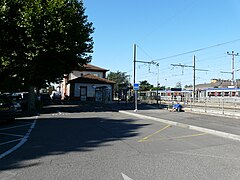 Muret railway station


Related pages[change | change source]
References[change | change source]
- ↑ "Les élus" (in French). Mairie de Muret. Archived from the original on 2 March 2017. Retrieved 13 March 2017.
- ↑ "Commune de Muret (31395)". Comparateur de territoire (in French). Institut national de la statistique et des études économiques - INSEE. Retrieved 13 March 2017.
- ↑ "Muret". Map-France.com. Retrieved 14 September 2016.
- ↑ "Muret (31600)" (in French). habitants.fr. Retrieved 14 September 2016.
- ↑ "Régions, départements, arrondissements, cantons et communes" (PDF). Populations légales 2014 (in French). Institut national de la statistique et des études économiques - INSEE. Retrieved 13 March 2017.
Other websites[change | change source]
- City Council website (in French)
| International | |
|---|---|
| National | |
| Geographic | |