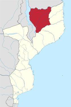
Niassa Province
13°15′S 36°30′E / 13.250°S 36.500°E
Niassa | |
|---|---|
 Niassa, Province of Mozambique | |
| Country | Mozambique |
| Capital | Lichinga |
| Area | |
| • Total | 129,056 km2 (49,829 sq mi) |
| Highest elevation | 1,836 m (6,024 ft) |
| Population (2017 census) | |
| • Total | 1,810,794 |
| • Density | 14/km2 (36/sq mi) |
| Postal code | 33xx |
| Area code | (+258) 271 |
| Website | www |
Niassa is a province of Mozambique. The capital city is Lichinga.
The Ruvuma River forms much of the northern boundary of the province with Tanzania. Lake Niassa forms the western border of the province, separating it from Malawi. The province shares the Niassa National Reserve with neighboring Cabo Delgado Province.[1]
Districts[change | change source]
Niassa Province is divided into the 15 districts of:
- Cuamba District
- Lago District
- Lichinga District
- Majune District
- Mandimba District
- Marrupa District
- Maúa District
- Mavago District
- Mecanhelas District
- Mecula District
- Metarica District
- Muembe District
- N'gauma District
- Nipepe District
- Sanga District
and the municipalities of:
References[change | change source]
- ↑ "The Lions of Niassa". Fauna and Flora International. 2009. Archived from the original on November 3, 2009. Retrieved 2009-12-31.
