
Niederglatt
Niederglatt | |
|---|---|
 Coat of arms | |
Location of Niederglatt  | |
 Niederglatt  Niederglatt | |
| Coordinates: 47°31′N 8°30′E / 47.517°N 8.500°E | |
| Country | Switzerland |
| Canton | Zurich |
| District | Dielsdorf |
| Area | |
| • Total | 3.6 km2 (1.4 sq mi) |
| Elevation | 411 m (1,348 ft) |
| Population (31 December 2018)[2] | |
| • Total | 4,954 |
| • Density | 1,400/km2 (3,600/sq mi) |
| Time zone | UTC+01:00 (Central European Time) |
| • Summer (DST) | UTC+02:00 (Central European Summer Time) |
| Postal code(s) | 8172 |
| SFOS number | 0089 |
| Surrounded by | Höri, Neerach, Niederhasli, Oberglatt, Steinmaur |
| Website | www SFSO statistics |
Niederglatt is a municipality in the district of Dielsdorf in the canton of Zurich in Switzerland.
Gallery
[change | change source]-
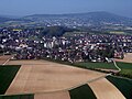 Niederglatt
 -
 Niederglatt
 -
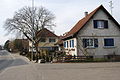
 Postoffice
 -
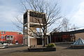
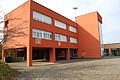 School
 -
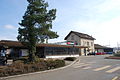 Niederglatt train station
 -
 Restaurant Löwen
 -
 Church of Niederglatt


References
[change | change source]- ↑ 1.0 1.1 "Arealstatistik Standard - Gemeinden nach 4 Hauptbereichen". Federal Statistical Office. Retrieved 13 January 2019.
- ↑ "Ständige Wohnbevölkerung nach Staatsangehörigkeitskategorie Geschlecht und Gemeinde; Provisorische Jahresergebnisse; 2018". Federal Statistical Office. 9 April 2019. Retrieved 11 April 2019.
Other websites
[change | change source]![]() Media related to Niederglatt at Wikimedia Commons
Media related to Niederglatt at Wikimedia Commons
- Official Website (in German)