Nordreisa
Nordreisa kommune
Ráissa suohkan Raisin komuuni | |
|---|---|
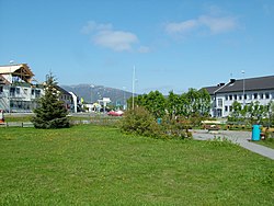
 View of Storslett | |
 Nordreisa within | |
| Coordinates: 69°42′18″N 21°12′33″E / 69.70500°N 21.20917°E | |
| Country | Norway |
| Established | 1 Jan 1886 |
| Administrative centre | Storslett |
| Government | |
| • Mayor (2019) | Hilde Anita Nyvoll (Ap) |
| Area | |
| • Total | 3,437.81 km2 (1,327.35 sq mi) |
| • Land | 3,334.74 km2 (1,287.55 sq mi) |
| • Water | 103.07 km2 (39.80 sq mi) 3% |
| • Rank | 9 in Norway |
| Population (2022)[2] | |
| • Total | 4,746 |
| • Rank | 183 in Norway |
| • Density | 1.4/km2 (4/sq mi) |
| • Change (10 years) | −1.3% |
| Demonym | Reisaværing[3] |
| Time zone | UTC+01:00 (CET) |
| • Summer (DST) | UTC+02:00 (CEST) |
| ISO 3166 code | NO-5428 |
| Official language form | Bokmål[4] |
| Preceded by | Skjervøy Municipality |
Nordreisa (Northern Sami: Ráisa ˈraːjːsa; Kven: Raisa)[5] is a municipality in Troms county, Norway.[6] It was created on January 1, 1886, when Skjervøy Municipality was split in two.[7] The southern part of Skjervøy was broken to form the new municipality. It has an area of 3,437 square kilometres (1,327 sq mi). Its administrative center is the village of Storslett, where the river Reisaelva meets the Reisafjorden. Other villages in the municipality include Oksfjordhamn, Sørkjosen, and Rotsund.[8]
Etymology
[change | change source]The municipality is named after the Reisafjorden, named after the river Reisaelva. The prefix Nord- was added to the name to distinguish the municipality from the nearby Sørreisa Municipality to the south.[9] The coat of arms of Nordreisa has two salmon, which were chosen to represent the local Reisaelva river.[10][11][12]
History
[change | change source]Most people living in Nordreisa have ancestors who were settlers from Finland who came over in the 18th century, escaping famine and war. Some people living there have Sámi or Norwegian ancestors. Today the Norwegian language is most commonly used. Few old buildings survive in Nordreisa; virtually everything was destroyed in early 1945 by retreating German troops. However, in the old trading post at Havnnes, there are old homes that escaped the damages of the war. There is also the waterfall of Mollisfossen, which is 269 metres (883 ft) high.[8]
Government
[change | change source]All municipalities in Norway, including Nordreisa, are run by a municipal council. The members of that council, will again choose a mayor in 2027. The municipality is in charge of things like schools, healthcare for people who don't stay in the hospital, support for senior citizens or older adults, helping people without jobs, planning land use, improving the economy, and keeping the roads in good shape. Nordreisa's legal cases are handled by the Nord-Troms District Court and the Hålogaland Court of Appeal.[13]
Geography
[change | change source]Nordreisa Municipality is located by a fjord and a valley. It also includes part of an island and a mountain. Other municipalities and countries surround it.
Climate
[change | change source]The weather is mostly cold, and the rainy season is in the autumn. It can get very hot in the summer sometimes. The highest temperature recorded was 31.6 °C (88.9 °F) in August 2018. A weather station has been there since 1974 to record the weather.[14][15][16][17]
Related pages
[change | change source]References
[change | change source]- ↑ "09280: Area of land and fresh water (km²) (M) 2007 - 2023. Statbank Norway". SSB. Retrieved 2023-05-02.
- ↑ "06913: Population 1 January and population changes during the calendar year (M) 1951 - 2023. Statbank Norway". SSB. Retrieved 2023-05-02.
- ↑ "Navn på steder og personer: Innbyggjarnamn" (in Norwegian). Språkrådet.
- ↑ "Forskrift om målvedtak i kommunar og fylkeskommunar" (in Norwegian). Lovdata.no.
- ↑ "Saksprotokoll fra Nordreisa kommunestyre 26.10.17 - PS 52/17". Nordreisa kommune. Archived from the original on November 28, 2020. Retrieved May 1, 2023.
- ↑ Mæhlum, Lars (2023-02-06), "Troms og Finnmark", Store norske leksikon (in Norwegian), archived from the original on 2019-10-27, retrieved May 2, 2023
- ↑ Juvkam, Dag. "Historisk oversikt over endringer i kommune- og fylkesinndelingen" (PDF). Statistisk sentralbyrå (in Norwegian). ISBN 82-537-4684-9. ISSN 0806-2056. Archived (PDF) from the original on January 9, 2018. Retrieved May 1, 2023.
- ↑ 8.0 8.1 Thorsnæs, Geir; Engerengen, Lars (2023-01-26), "Nordreisa", Store norske leksikon (in Norwegian), archived from the original on 2023-05-02, retrieved 2023-05-02
- ↑ Rygh, Oluf (1911). Norske gaardnavne: Tromsø amt (in Norwegian) (17 ed.). Kristiania, Norge: W. C. Fabritius & sønners bogtrikkeri. p. 185. Archived from the original on 2023-05-13. Retrieved 2023-05-02.
- ↑ "Civic heraldry of Norway - Norske Kommunevåpen". Heraldry of the World. Archived from the original on May 20, 2023. Retrieved May 1, 2023.
- ↑ "Nordreisa, Troms (Norway)". Flags of the World. Archived from the original on May 20, 2023. Retrieved May 1, 2023.
- ↑ "Godkjenning av våpen og flagg". Lovdata.no (in Norwegian). Norges kommunal- og arbeidsdepartementet. 1984-12-21. Archived from the original on 2023-01-29. Retrieved May 1, 2023.
- ↑ Hansen, Tore, ed. (2016-05-12). "kommunestyre". Store norske leksikon (in Norwegian). Kunnskapsforlaget. Archived from the original on 2019-03-27. Retrieved 2018-08-02.
- ↑ "eKlima Web Portal". Norwegian Meteorological Institute. Archived from the original on 2004-06-14. Retrieved May 2, 2023.
- ↑ "yr.no". NRK. Archived from the original on May 2, 2023. Retrieved May 2, 2023.
- ↑ "Scorching Scandinavia: Record-breaking heat hits Norway, Finland and Sweden". Washington Post. ISSN 0190-8286. Archived from the original on March 21, 2023. Retrieved May 2, 2023.
- ↑ "eKlima Web Portal". Norwegian Meteorological Institute. Archived from the original on 2004-06-14. Retrieved May 2, 2023.

