North Arlington, New Jersey
North Arlington, New Jersey | |
|---|---|
 Belleville Turnpike Bridge | |
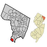
 Location of North Arlington in Bergen County highlighted in red (left). Inset map: Location of Bergen County in New Jersey highlighted in orange (right). | |
 Census Bureau map of North Arlington, New Jersey | |
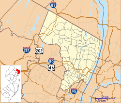
Location in Bergen County Location in New Jersey | |
| Coordinates: 40°47′11″N 74°07′34″W / 40.786256°N 74.12622°W[1][2] | |
| Country | |
| State | |
| County | Bergen |
| Incorporated | March 9, 1896 |
| Government | |
| • Type | Borough |
| • Body | Borough Council |
| Area | |
| • Total | 2.53 sq mi (6.55 km2) |
| • Land | 2.48 sq mi (6.43 km2) |
| • Water | 0.04 sq mi (0.12 km2) 1.78% |
| • Rank | 372th of 565 in state 38th of 70 in county[1] |
| Elevation | 85 ft (26 m) |
| Population | |
| • Total | 16,457 |
| • Rank | 161st of 565 in state 20th of 70 in county[8] |
| • Density | 6,625.2/sq mi (2,558.0/km2) |
| • Rank | 75th of 565 in state 23rd of 70 in county[8] |
| Time zone | UTC−05:00 (Eastern (EST)) |
| • Summer (DST) | UTC−04:00 (Eastern (EDT)) |
| ZIP Code | |
| Area code(s) | 201[11] |
| FIPS code | 3400352320[1][12][13] |
| GNIS feature ID | 0885323[1][14] |
| Website | www |
North Arlington is a borough in Bergen County, New Jersey, United States. As of the 2020 United States Census, the borough population was 16,457.[6] As the site of Holy Cross Cemetery, which has interred over 250,000 individuals since its establishment in 1915, North Arlington has over 15 times more dead people than living.[15]
References[change | change source]
- ↑ 1.0 1.1 1.2 1.3 2019 Census Gazetteer Files: New Jersey Places, United States Census Bureau. Accessed July 1, 2020.
- ↑ US Gazetteer files: 2010, 2000, and 1990, United States Census Bureau. Accessed September 4, 2014.
- ↑ 2012 New Jersey Legislative District Data Book, Rutgers University Edward J. Bloustein School of Planning and Public Policy, March 2013, p. 154.
- ↑ "ArcGIS REST Services Directory". United States Census Bureau. Retrieved October 11, 2022.
- ↑ U.S. Geological Survey Geographic Names Information System: Borough of North Arlington, Geographic Names Information System. Accessed March 8, 2013.
- ↑ 6.0 6.1 QuickFacts North Arlington borough, New Jersey, United States Census Bureau. Accessed January 31, 2023.
- ↑ Total Population: Census 2010 - Census 2020 New Jersey Municipalities, New Jersey Department of Labor and Workforce Development. Accessed December 1, 2022.
- ↑ 8.0 8.1 Population Density by County and Municipality: New Jersey, 2020 and 2021, New Jersey Department of Labor and Workforce Development. Accessed March 1, 2023.
- ↑ Look Up a ZIP Code for North Arlington, NJ, United States Postal Service. Accessed December 15, 2011.
- ↑ Zip Codes, State of New Jersey. Accessed August 18, 2013.
- ↑ Area Code Lookup - NPA NXX for North Arlington, NJ, Area-Codes.com. Accessed August 28, 2013.
- ↑ U.S. Census website, United States Census Bureau. Accessed September 4, 2014.
- ↑ Geographic Codes Lookup for New Jersey, Missouri Census Data Center. Accessed April 1, 2022.
- ↑ US Board on Geographic Names, United States Geological Survey. Accessed September 4, 2014.
- ↑ Holy Cross Cemetery, Roman Catholic Archdiocese of Newark. Retrieved February 15, 2007. Archived September 28, 2007, at the Wayback Machine


