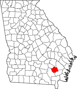
Pierce County, Georgia
Pierce County | |
|---|---|
 Pierce County Courthouse in Blackshear | |
 Location within the U.S. state of Georgia | |
 Georgia's location within the U.S. | |
| Coordinates: 31°22′N 82°13′W / 31.36°N 82.22°W | |
| Country | |
| State | |
| Founded | December 18, 1857 |
| Named for | Franklin Pierce |
| Seat | Blackshear |
| Largest city | Blackshear |
| Area | |
| • Total | 343 sq mi (890 km2) |
| • Land | 316 sq mi (820 km2) |
| • Water | 27 sq mi (70 km2) 7.8% |
| Population | |
| • Total | 19,716 |
| • Density | 62/sq mi (24/km2) |
| Time zone | UTC−5 (Eastern) |
| • Summer (DST) | UTC−4 (EDT) |
| Website | piercecountyga |
Pierce County is a county in the U.S. state of Georgia. As of the 2020 census, 19,716 people lived there.[1] The county seat is Blackshear.[2]
History[change | change source]
Pierce County is named after Franklin Pierce, 14th President of the United States (1853–1857). It was created on December 18, 1857 from parts of Appling and Ware counties.[3]
Geography[change | change source]
The U.S. Census Bureau says that the county has a total area of 343 square miles (890 km2). Of that 316 square miles (820 km2) is land and 27 square miles (70 km2) (7.8%) is water.[4]
Major highways[change | change source]
Bordering counties[change | change source]
- Appling County - north
- Wayne County - northeast
- Brantley County - southeast
- Ware County - west
- Bacon County - northwest
Demographics[change | change source]
| Historical population | |||
|---|---|---|---|
| Census | Pop. | %± | |
| 1860 | 1,973 | — | |
| 1870 | 2,778 | 40.8% | |
| 1880 | 4,538 | 63.4% | |
| 1890 | 6,379 | 40.6% | |
| 1900 | 8,100 | 27.0% | |
| 1910 | 10,749 | 32.7% | |
| 1920 | 11,934 | 11.0% | |
| 1930 | 12,522 | 4.9% | |
| 1940 | 11,800 | −5.8% | |
| 1950 | 11,112 | −5.8% | |
| 1960 | 9,678 | −12.9% | |
| 1970 | 9,281 | −4.1% | |
| 1980 | 11,897 | 28.2% | |
| 1990 | 13,328 | 12.0% | |
| 2000 | 15,636 | 17.3% | |
| 2010 | 18,758 | 20.0% | |
| 2020 | 19,716 | 5.1% | |
| U.S. Decennial Census[5] 1790-1960[6] 1900-1990[7] 1990-2000[8] 2010-2020[1] | |||
2010 census[change | change source]
The 2010 United States Census says that there were 18,758 people, 7,083 households, and 5,268 families living in the county.[9]
Communities[change | change source]
Cities[change | change source]
Unincorporated communities[change | change source]
References[change | change source]
- ↑ 1.0 1.1 1.2 "QuickFacts: Pierce County, Georgia". United States Census Bureau. Retrieved August 15, 2023.
- ↑ "Find a County". National Association of Counties. Retrieved 2011-06-07.
- ↑ Krakow, Kenneth K. (1975). Georgia Place-Names: Their History and Origins (PDF). Macon, GA: Winship Press. p. 176. ISBN 0-915430-00-2.
- ↑ "US Gazetteer files: 2010, 2000, and 1990". United States Census Bureau. 2011-02-12. Retrieved 2011-04-23.
- ↑ "U.S. Decennial Census". United States Census Bureau. Retrieved June 25, 2014.
- ↑ "Historical Census Browser". University of Virginia Library. Archived from the original on August 11, 2012. Retrieved June 25, 2014.
- ↑ "Population of Counties by Decennial Census: 1900 to 1990". United States Census Bureau. Retrieved June 25, 2014.
- ↑ "Census 2000 PHC-T-4. Ranking Tables for Counties: 1990 and 2000" (PDF). United States Census Bureau. Retrieved June 25, 2014.
- ↑ "DP-1 Profile of General Population and Housing Characteristics: 2010 Demographic Profile Data". United States Census Bureau. Archived from the original on February 13, 2020. Retrieved 2015-12-30.

