Ramapo, New York
Ramapo, New York | |
|---|---|
 Downtown Suffern, a village in Ramapo | |
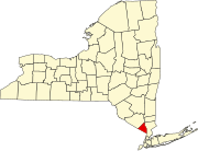
 Location in Rockland County and the state of New York. | |
| Coordinates: 41°7′19″N 74°5′0″W / 41.12194°N 74.08333°W | |
| Country | United States |
| State | New York |
| County | Rockland |
| Area | |
| • Total | 61.84 sq mi (160.16 km2) |
| • Land | 61.14 sq mi (158.35 km2) |
| • Water | 0.70 sq mi (1.80 km2) |
| Elevation | 371 ft (113 m) |
| Population | |
| • Total | 148,919 |
| • Density | 2,435.6/sq mi (940.4/km2) |
| Time zone | UTC-5 (Eastern (EST)) |
| • Summer (DST) | UTC-4 (EDT) |
| ZIP code | 10901, 10952, 10977, 10970, 10965, 10974 |
| Area code | 845 |
| FIPS code | 36-60510 |
| GNIS ID | 0979406 |
| Website | ramapo.org |
Ramapo is a town in Rockland County, New York, United States. It was originally formed as New Hampstead, in 1791.[3] It shares its name with the Ramapo River. As of the 2020 census, Ramapo had a total population of 148,919.[2]
References[change | change source]
- ↑ "2016 U.S. Gazetteer Files". United States Census Bureau. Retrieved Jul 5, 2017.
- ↑ 2.0 2.1 "QuickFacts: Ramapo town, Rockland County, New York". United States Census Bureau. Retrieved March 8, 2024.
- ↑ "Ramapo", in Peter R. Eisenstadt and Laura-Eve Moss (Eds.), The Encyclopedia of New York State. Syracuse, NY: Syracuse University Press. ISBN 9780815608080. p. 1284.

