
Sumiswald
Sumiswald | |
|---|---|
 Coat of arms | |
Location of Sumiswald  | |
 Sumiswald  Sumiswald | |
| Coordinates: 47°2′N 7°43′E / 47.033°N 7.717°E | |
| Country | Switzerland |
| Canton | Bern |
| District | Emmental |
| Government | |
| • Mayor | Roland Holzer |
| Area | |
| • Total | 59.4 km2 (22.9 sq mi) |
| Elevation | 702 m (2,303 ft) |
| Population (31 December 2018)[2] | |
| • Total | 5,046 |
| • Density | 85/km2 (220/sq mi) |
| Time zone | UTC+01:00 (Central European Time) |
| • Summer (DST) | UTC+02:00 (Central European Summer Time) |
| Postal code(s) | 3454 |
| SFOS number | 0957 |
| Surrounded by | Affoltern im Emmental, Dürrenroth, Eriswil, Langnau im Emmental, Luthern (LU), Lützelflüh, Rüegsau, Trachselwald, Trub, Wyssachen |
| Website | www SFSO statistics |
Sumiswald is a municipality of the administrative district of Emmental in the canton of Bern in Switzerland.
Gallery[change | change source]
-
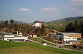 Sumiswald
 -
 Gasthof Bären
 -
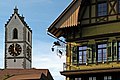
 Church of Sumiswald
 -
 Sumiswald Castle


References[change | change source]
- ↑ 1.0 1.1 "Arealstatistik Standard - Gemeinden nach 4 Hauptbereichen". Federal Statistical Office. Retrieved 13 January 2019.
- ↑ "Ständige Wohnbevölkerung nach Staatsangehörigkeitskategorie Geschlecht und Gemeinde; Provisorische Jahresergebnisse; 2018". Federal Statistical Office. 9 April 2019. Retrieved 11 April 2019.
Other websites[change | change source]
![]() Media related to Sumiswald at Wikimedia Commons
Media related to Sumiswald at Wikimedia Commons
- Official website (in German)