Telford, Tennessee
Appearance
Telford, Tennessee | |
|---|---|
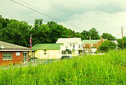
 Buildings along Mill Street in the town. | |
| Coordinates: 36°14′56″N 82°32′43″W / 36.24889°N 82.54528°W | |
| Country | United States |
| State | Tennessee |
| County | Washington |
| Area | |
| • Total | 2.469 sq mi (6.39 km2) |
| • Land | 2.469 sq mi (6.39 km2) |
| • Water | 0 sq mi (0 km2) |
| Elevation | 1,555 ft (474 m) |
| Population | |
| • Total | 909 |
| • Density | 370/sq mi (140/km2) |
| Time zone | UTC-5 (Eastern (EST)) |
| • Summer (DST) | UTC-4 (EDT) |
| ZIP code | 37690[3] |
| Area code | 423 |
Telford is a census-designated place and unincorporated community in Washington County, Tennessee, United States, located between Jonesborough and Limestone. As of the 2020 census, it had a population of 909.[2] The area is a part of the Johnson City–Kingsport–Bristol, TN-VA Combined Statistical Area – commonly known as the "Tri-Cities" region.
History
[change | change source]During the Civil War, citizens of this part of Washington County voted to secede from the Confederacy. They were unsuccessful in getting others to do so. The independent nation called "Bricker's Republic" soon was forgotten.[4] A Civil War battle took place in Telford on September 8, 1863.
Notable people
[change | change source]- Eliza McCardle Johnson, First Lady of the United States, (April 15, 1865 – March 4, 1869) Husband to Andrew Johnson
References
[change | change source]- ↑ "US Gazetteer files: 2010, 2000, and 1990". United States Census Bureau. 2011-02-12. Retrieved 2011-04-23.
- ↑ 2.0 2.1 "Profile of General Population and Housing Characteristics: 2020 Demographic Profile Data (DP-1): Telford CDP, Tennessee". United States Census Bureau. Retrieved March 18, 2024.
- ↑ United States Postal Service (2012). "USPS – Look Up a ZIP Code". Retrieved 2012-02-15.
- ↑ Paul Fink, Jonesborough (2002 printing), p. 87.


