Teltow-Fläming
Teltow-Fläming | |
|---|---|
 | |
| Coordinates: 52°5′N 13°18′E / 52.083°N 13.300°E | |
| Country | Germany |
| State | Brandenburg |
| Capital | Luckenwalde |
| Area | |
| • Total | 2,092.0 km2 (807.7 sq mi) |
| Population (31 December 2021)[1] | |
| • Total | 172,545 |
| • Density | 82/km2 (210/sq mi) |
| Time zone | UTC+01:00 (CET) |
| • Summer (DST) | UTC+02:00 (CEST) |
| Vehicle registration | TF |
| Website | teltow-flaeming.de |
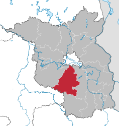
Teltow-Fläming is a Kreis (district) in the southwestern part of Brandenburg, Germany. The district was made in December 1993 by joining the old districts of Luckenwalde, Jüterbog and Zossen, but also including small parts from other former districts such as Luckau.
Fläming-Skate is a 160 km long route specially for inline skating, the only such route in Germany.
Curiously, the town of Teltow is not a part of the district Teltow-Fläming, just as the town of Dahme is not a part of the district of Dahme-Spreewald.
Coat of arms[change | change source]

|
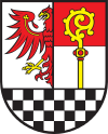
The coat of arms show the eagle of Brandenburg to the left, as the margraves of Brandenburg began to rule the northern and northwestern part of the district in the 13th century. To the right is a staff of an abbot. It is for Magdeburg, which was ruled by a bishop. The southern and middle part of the district belonged to Magdeburg. The black-and-white chequered bottom derives from the coat of arms of the family of Torgow, who owned the area around Zossen until 1478.
After the creation of the new district a public contest was held to create a coat of arms for the district. Out of ten proposals the parliament of the district selected the one made by the designer Horst Nehls from Merow. The coat of arms were officially granted by the Ministry of the Interior of Brandenburg on November 21 1996. |
Towns and municipalities[change | change source]
| Amt-free towns | Amt-free municipalities | Amt |
|---|---|---|
|
|
1. Dahme/Mark
|
References[change | change source]
Other websites[change | change source]
- Official website (in German)
- Fläming-Skate (in German)


