West Warwick, Rhode Island
West Warwick, Rhode Island | |
|---|---|
 War Memorial Park West Warwick | |
| Nickname: The Center of Rhode Island | |
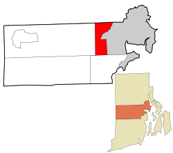
 Location in Kent County and the state of Rhode Island. | |
| Coordinates: 41°42′N 71°31′W / 41.700°N 71.517°W | |
| Country | United States |
| State | Rhode Island |
| County | Kent |
| Area | |
| • Total | 8.1 sq mi (21.0 km2) |
| • Land | 7.9 sq mi (20.5 km2) |
| • Water | 0.2 sq mi (0.5 km2) |
| Elevation | 269 ft (82 m) |
| Population | |
| • Total | 31,012 |
| • Density | 3,918/sq mi (1,512.8/km2) |
| Time zone | UTC−5 (Eastern (EST)) |
| • Summer (DST) | UTC−4 (EDT) |
| ZIP code | 02893 |
| Area code | 401 |
| FIPS code | 44-78440[3] |
| GNIS feature ID | 1220060[1] |
West Warwick is a town in Kent County, Rhode Island, United States. The population was 31,012 at the 2020 census.[2]
References[change | change source]
- ↑ 1.0 1.1 U.S. Geological Survey Geographic Names Information System: West Warwick, Rhode Island
- ↑ 2.0 2.1 "QuickFacts: West Warwick town, Kent County, Rhode Island". U.S. Census Bureau. Retrieved August 3, 2023.
- ↑ "U.S. Census website". United States Census Bureau. Retrieved 2008-01-31.


