Capellen
Capellen
Capellen | |
|---|---|
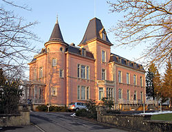
 Capellen castle. | |
| Coordinates: 49°38′40″N 5°59′23″E / 49.64444°N 5.98972°E | |
| Country | |
| Canton | Capellen |
| Commune | Mamer |
| Government | |
| • Mayor | Gilles Roth |
| Area | |
| • Total | 3.2 km2 (1.2 sq mi) |
| Highest elevation | 323 m (1,060 ft) |
| Population (2015)[1] | |
| • Total | 1,677 |
| • Density | 520/km2 (1,400/sq mi) |
| Time zone | UTC+1 (CET) |
| • Summer (DST) | UTC+2 (CEST) |
Capellen (Luxembourgish: Capellen, German: Capellen) is a town in the commune of Mamer, in south-western Luxembourg, 12 km (7.5 mi) west of Luxembourg City.
Despite not having a commune named after it, Capellen gives its name to the canton of Capellen.
History[change | change source]
Capellen lies on the old Roman road, today's Kiemwee, from Trier in Germany to Reims and Paris.
When Luxembourg was divided into cantons in 1840, as a result of disputes between Mamer and Koerich, it was decided that the canton should be named Capellen and that Capellen should become the capital of the canton.
Geography[change | change source]
Capellen has an area of 3.2 km2 (1.2 sq mi). The altitude at the church is 323 m (1,060 ft) high.[1]
Population[change | change source]
There were 1,677, persons living in the commune in 2015,[1] for a population density of 524.1 inhabitants/km².
References[change | change source]
- ↑ 1.0 1.1 1.2 1.3 "Surface area of the cantons and municipalities". Statistics Portal - Grand Duchy of Luxembourg. Retrieved 27 May 2016.
Related pages[change | change source]
Other websites[change | change source]
- Commune of Mamer official website (in French)
