Trier
Trier | |
|---|---|
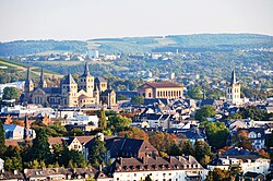
 View over Trier | |
| Coordinates: 49°45′N 6°38′E / 49.750°N 6.633°E | |
| Country | Germany |
| State | Rhineland-Palatinate |
| District | Urban district |
| Government | |
| • Lord mayor | Wolfram Leibe (SPD) |
| Area | |
| • Total | 117.13 km2 (45.22 sq mi) |
| Elevation | 137 m (449 ft) |
| Population (2021-12-31)[1] | |
| • Total | 110,570 |
| • Density | 940/km2 (2,400/sq mi) |
| Demonym | Trevian |
| Time zone | UTC+01:00 (CET) |
| • Summer (DST) | UTC+02:00 (CEST) |
| Postal codes | 54290–54296 (except 54291) |
| Dialling codes | 0651 |
| Vehicle registration | TR |
| Website | www |

Trier is a city at the Moselle River in Rhineland-Palatinate in Germany. The population is about 100,000.
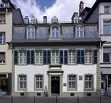
Trier is famous for some Roman buildings like the Porta Nigra and others. It is famous as the birthplace of Karl Marx. Trier is also famous for the wine of the wine-growing-region Mosel-Saar-Ruwer.
Districts[change | change source]
The districts of Trier with area and inhabitants (July 2007):
| District with official numbers and their associated sub-districts | Area in km² | Inhabitants |
|---|---|---|
| 11 Mitte/Gartenfeld | 2.978 | 12,648 |
| 12 Nord (Nells Ländchen, Maximin) | 3.769 | 14,256 |
| 13 Süd (St. Barbara, St. Matthias or St. Mattheis) | 1.722 | 9,409 |
| 21 Ehrang/Quint | 26.134 | 9,397 |
| 22 Pfalzel | 2.350 | 3,558 |
| 23 Biewer | 5.186 | 1,985 |
| 24 Ruwer/Eitelsbach | 9.167 | 3,142 |
| 31 West/Pallien | 8.488 | 7,117 |
| 32 Euren (Herresthal) | 13.189 | 4,116 |
| 33 Zewen (Oberkirch) | 7.496 | 3,695 |
| 41 Olewig | 3.100 | 3,312 |
| 42 Kürenz (Alt-Kürenz, Neu-Kürenz) | 5.825 | 8,578 |
| 43 Tarforst | 4.184 | 6,827 |
| 44 Filsch | 1.601 | 830 |
| 45 Irsch | 4.082 | 2,410 |
| 46 Kernscheid | 3.768 | 999 |
| 51 Feyen/Weismark | 5.095 | 5,845 |
| 52 Heiligkreuz (Alt-Heiligkreuz, Neu-Heiligkreuz, St. Maternus) | 2.036 | 6,766 |
| 53 Mariahof (St. Michael) | 7.040 | 3,212 |
References[change | change source]
Other websites[change | change source]
![]() Media related to Trier at Wikimedia Commons
Media related to Trier at Wikimedia Commons
- www.trier.de
- History of Trier Archived 2005-08-28 at the Wayback Machine (German and English)
- Another Trier Daily Photo


