
Erfurt
Erfurt | |
|---|---|
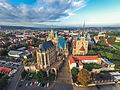
 Krämerbrücke from above | |
|
Flag  Coat of arms | |
Location of Erfurt  | |
 Erfurt  Erfurt | |
| Coordinates: 50°59′0″N 11°2′0″E / 50.98333°N 11.03333°E | |
| Country | Germany |
| State | Thuringia |
| District | Urban district |
| Subdivisions | 53 districts |
| Government | |
| • Lord mayor | Andreas Bausewein (SPD) |
| • Governing parties | SPD |
| Area | |
| • Total | 269.17 km2 (103.93 sq mi) |
| Highest elevation | 430 m (1,410 ft) |
| Lowest elevation | 158 m (518 ft) |
| Population (2022-12-31)[1] | |
| • Total | 214,969 |
| • Density | 800/km2 (2,100/sq mi) |
| Time zone | UTC+01:00 (CET) |
| • Summer (DST) | UTC+02:00 (CEST) |
| Postal codes | 99001-99198 |
| Dialling codes | 0361 |
| Vehicle registration | EF |
| Website | www.erfurt.de |
Erfurt is the capital city of the German state of Thuringia. It has an area of 269.17 km2 (103.9 sq mi). In December 2015 it had a population of 210,000 people.[2] The River Gera runs through the city.
History[change | change source]
People have lived in the area for about 100,000 years. The city was first mentioned in writing in 742, in a letter to the Pope from St Boniface. St Boniface established Christianity in the area. He set up a church in Erfurt in 742. Erfurt Cathedral was later built on the same site.[3][4]
The city is in the centre of Germany. It was on the Via Regia, a medieval trade road network that stretched across Europe. It became an important trading centre in the Middle Ages. Erfurt was a member of the Hanseatic League, an alliance of trade associations and market towns. It was also famous for producing woad. Blue indigo dye is made from the woad plant.[5][6]
Erfurt is on the Way of St. James pilgrams' path (Spanish: Camino de Santigo; German: Jakobsweg). In the Middle Ages a number of monasteries were set up in the city. Martin Luther, the father of the Reformation, lived at St. Augustine's Monastery from 1505 until 1511. A famous philosopher and theologian called Meister Eckhart lived at the Dominican Monastery from about 1275 until 1311.[5]
The city was part of the Holy Roman Empire. It became part of the Kingdom of Prussia in 1802. From 1949 until 1990 Erfurt was in the communist German Democratic Republic (East Germany).[5]
Seventeen people were killed in a mass shooting in 2002.
Industry[change | change source]
Modern day Erfurt is a transport hub for high speed trains and other German and European transport networks. This makes logistics one of its main industries. Other important industries are agriculture, horticulture and microelectronics.[6]
The German Federal Labour Court (German:Bundesarbeitsgericht) is in Erfurt.
Education[change | change source]
The University of Erfurt was first set up in 1379. It closed in 1816, but was reopened in 1994. Martin Luther studied there from 1501 to 1505.[5] It is also thought that Johannes Gutenberg, who developed the printing press, enrolled there in 1418.[7][8] Erfurt also has a Fachhochschule, a University of Applied Sciences.
Tourist attractions[change | change source]
Many visitors come to see the historic medieval town centre. One of the main tourist attractions is the Krämerbrücke (the Merchants' Bridge). The bridge was built in its current form in 1472. It has buildings with shops and houses on it. People still live on it.[6]
The city is well known for its festivals throughout the year. Two million people visit the Christmas markets each year.[9]
Other important sites in the city include:
- St. Augustine's Monastery, where Martin Luther lived from 1505 to 1511. It has been nominated as a World Heritage Site.[10]
- The Old Synagogue, which dates back to the 11th and 12th centuries. It is one of the oldest synagogues in Europe and it has been nominated as a World Heritage Site.[11]
- Erfurt Cathedral and the Severikirche (St. Severus Church), which overlook Domplatz, the Cathedral square.
- Petersberg Citadel, a 16th-century fortress on a hill overlooking the town centre. It is one of the largest and best preserved town fortresses in Europe.[12]
Gallery[change | change source]
-
 St. Augustine's Monastery
 -
 Old Synagogue, c.1100 - 1300.
 -
 Erfurt Cathedral and Severikirche
 -
 Michaelisstraße, Erfurt
 -
 Krämerbrücke
 -
 Krämerbrücke
 -
 River Gera in town centre
 -
 Entrance to Petersberg Citadel
 -
 Lookout point, Petersberg Citadel
 -
 Collegium Maius - rebuilt University building
 -
 Federal Labour Court, Erfurt
 -
 Erfurt Rathaus (Town hall)
 -
 Erfurt Christmas market


.JPG)
.JPG)


.jpg)

References[change | change source]
- ↑ "Bevölkerung der Gemeinden, erfüllenden Gemeinden und Verwaltungsgemeinschaften in Thüringen Gebietsstand: 31.12.2022" (in German). Thüringer Landesamt für Statistik. June 2023.
- ↑ www.citypopulation.de.Erfurt. Retrieved 3 July 2017
- ↑ Heinemeyer, Karl (2004). "Bonifatius in Mitteldeutschland". In Hardy Eidam; Marina Moritz; Gerd-Rainer Riedel; Kai-Uwe Schierz (eds.). Bonifatius: Heidenopfer, Christuskreuz, Eichenkult (in German). Stadtverwaltung Erfurt. pp. 73–87.
- ↑ Christoph Engels, (2010) '1000 Sacred Places', Tandem Verlag GmbH, p 55
- ↑ 5.0 5.1 5.2 5.3 Raßloff, Steffen (2012) Geschichte der Stadt Erfurt. Erfurt: Sutton Verlag.
- ↑ 6.0 6.1 6.2 Stade, Heinz, et. al (2015) Erfurt: eine Stadt im Wandel, Leipzig: Edition Leipzig.
- ↑ Martin, Henri-Jean (1995). "The arrival of print". The History and Power of Writing. University of Chicago Press. p. 217. ISBN 0-226-50836-6.
- ↑ Dudley, Leonard (2008). "The Map-maker's son". Information revolutions in the history of the West. Northampton, MA: Edward Elgar. p. 78. ISBN 978-1-84720-790-6.
- ↑ The official Erfurt Christmas Market Portal . Retrieved 4 July 2017
- ↑ UNESCO World Heritage. Augustinian Monastery, Erfurt extension application Archived 2017-08-04 at the Wayback Machine. Retrieved 29 May 2017.
- ↑ Permanent Delegation of Germany to UNESCO (2015) Old synagogue and Mikveh in Erfurt - UNESCO world heritage centre. Retrieved 04 June 2017
- ↑ Petersberg - Erfurt-web.de (in German) Retrieved 05 July 2017).
Other websites[change | change source]
- Erfurt City official website Archived 2005-04-11 at the Wayback Machine
| Urban districts | |
|---|---|
| Rural districts | |
| International | |
|---|---|
| National | |
| Geographic | |
| Other | |