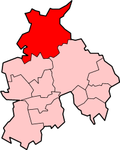
City of Lancaster
| City of Lancaster | |
|---|---|
 Shown within Lancashire | |
| Geography | |
| Status: | City (1937) |
| Region: | North West England |
| Admin. County: | Lancashire |
| Area: - Total |
Ranked 85th 575.86 km² |
| Admin. HQ: | Lancaster |
| ONS code: | 30UH |
| Demographics | |
| Population: - Total (2005 est.) - Density |
Ranked 129th 138,000 240 / km² |
| Ethnicity: | 95.5% All White 2.5% All Asian 0.9% All Mixed 0.5% All Black 0.5% All Other |
| Politics | |
| Leadership: | Leader & Cabinet |
| Executive: | Labour / Liberal Democrats / Green |
| MPs: | Ben Wallace, Geraldine Smith |
The City of Lancaster (2002 population: 133,914) is a local government district in Lancashire, England. Its main town is Lancaster, from which it obtained its city status. Other towns in the district include Morecambe, Heysham, Slyne, and Carnforth.
History[change | change source]
The district was made on April 1 1974, under the Local Government Act 1972, when the boroughs of Lancaster and Morecambe and Heysham, along with Carnforth urban district, Lancaster Rural District and Lunesdale Rural District joined together.
Population[change | change source]
| Ethnic Group | City of Lancaster | North West | England |
|---|---|---|---|
| White British | 95.5% | 92.9% | 89.1% |
| White Irish | 0.8% | 1.1% | 1.2% |
| Other White | 2.7% | 1.5% | 3.2% |
| Mixed White and Black | 0.4% | 0.6% | 0.7% |
| Mixed White and Asian | 0.3% | 0.3% | 0.5% |
| Other Mixed | 0.2% | 0.3% | 0.4% |
| Indian | 0.9% | 1.3% | 2.4% |
| Pakistani | 0.4% | 2.0% | 1.6% |
| Bangladeshi | 0.2% | 0.5% | 0.6% |
| Other Asian | 0.2% | 0.3% | 0.6% |
| Black Caribbean | 0.2% | 0.4% | 1.2% |
| Black African | 0.3% | 0.5% | 1.3% |
| Black Other | 0.0% | 0.1% | 0.2% |
| Chinese | 0.9% | 0.6% | 0.7% |
| Other Ethnic Group | 0.5% | 0.3% | 0.6% |
