Helmand Province
Helmand
هلمند | |
|---|---|
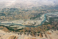
 Helmand River and the town of Grishk | |
 Map of Afghanistan with Helmand highlighted | |
| Coordinates (Capital): 31°00′N 64°00′E / 31.0°N 64.0°E | |
| Country | |
| Capital | Lashkargah |
| Government | |
| • Governor | Maulvi Abdul Ahad Talib |
| • Deputy Governor | Mulavi Hizbullah[1] |
| Area | |
| • Total | 58,584 km2 (22,619 sq mi) |
| Population (2021)[2] | |
| • Total | 1,472,162 |
| • Density | 25/km2 (65/sq mi) |
| Time zone | UTC+4:30 (Afghanistan Time) |
| ISO 3166 code | AF-HEL |
| Main languages | Pashto Dari |
Helmand (Pashto/Dari: هلمند) is one of the 34 provinces of Afghanistan. It is in the southwest of the country. Its capital is Lashkar Gah. The Helmand River flows through the mainly desert region, providing water for irrigation.
Helmand is the world's largest opium-producing region. It makes 75% of the world's total production.[3][4] This is more than all of Burma, which is the second largest producing nation after Afghanistan. Afghan opium accounts for more than 90% of the global supply.
The current governor is Mohammad Golab Mangal (since March 2008).
Much of the fighting between NATO and Taliban forces is taking place in this province. Helmand is said to be a Taliban stronghold.
Border with Pakistan[change | change source]
Helmand has a southern border with the Balochistan province of Pakistan. Many domestic and international observers have criticized Pakistan's efforts towards securing the border against Taliban insurgents.
Cities[change | change source]

Demographics[change | change source]
The population is 1,441,769. The area is 58,584 square kilometres. Pashtuns are the majority estimated at 92% of the population.[5][6] There are also Balochs who are in the south. Also there are small numbers of Hazara, Brahui and Tajik.[7]
Districts[change | change source]
| District | Capital | Population[8] | Area[9] | Notes |
|---|---|---|---|---|
| Baghran | 129,947 | |||
| Dishu | 29,005 | |||
| Garmsir | 107,153 | |||
| Nahri Saraj | 166,827 | also known as Nahre Saraj | ||
| Kajaki | 119,023 | |||
| Khanashin (Reg) | 17,333 | |||
| Lashkargah | 201,546 | |||
| Musa Qala | Musa Qala | 138,896 | ||
| Nad Ali | 235,590 | |||
| Nawa-I-Barakzayi | 89,814 | |||
| Nawzad | 108,258 | |||
| Sangin | Sangin | 213,901 | ||
| Washir | 31,476 |
References[change | change source]
- ↑ بلال, رضوان الله (23 December 2021). "د هلمند له زندانه ۲۱۸ روږدي له درملنې وروسته کورونو ته ولېږل شول".
- ↑ "Estimated Population of Afghanistan 2021-22" (PDF). nsia.gov.af. National Statistic and Information Authority (NSIA). April 2021. Archived from the original (PDF) on June 24, 2021. Retrieved June 29, 2021.
- ↑
Pat McGeough (2007-03-05). "Where the poppy is king". Sydney Morning Herald. Archived from the original on 2010-02-03.
More than 90 per cent of the province's arable land is choked with the hardy plant. A 600-strong, US-trained eradication force is hopelessly behind schedule on its target for this growing season in Helmand - to clear about a third of the crop, which is estimated to be a head-spinning 70,000 hectares.
- ↑
"Afghanistan still the largest producer of opium: UN report". Zee News. Archived from the original on 2010-02-03.
She said opium cultivation is concentrated in the south of the country, with just one province 'Helmand' accounting for 42 percent of all the illicit production in the world. Many of the provinces with the highest levels of production also have the worst security problems.
- ↑ "Helmand provincial profile" (PDF). Archived from the original (PDF) on 2009-09-02. Retrieved 2012-04-15.
- ↑ Helmand Executive Summary, nps.edu
- ↑ NPS.edu
- ↑ "MRRD.gov.af" (PDF). Archived from the original (PDF) on 2009-09-02. Retrieved 2012-04-15.
- ↑ Afghanistan Geographic & Thematic Layers
