
Molise
Molise | |
|---|---|
 Flag  Coat of arms | |
 | |
| Country | Italy |
| Capital | Campobasso |
| Government | |
| • President | Paolo Di Laura Frattura[1] |
| Area | |
| • Total | 4,460.65 km2 (1,722.27 sq mi) |
| Population (1 January 2017)[2] | |
| • Total | 310,449 |
| • Density | 70/km2 (180/sq mi) |
| Demonym | molisani |
| Time zone | UTC+1 (CET) |
| • Summer (DST) | UTC+2 (CEST) |
| GDP/ Nominal | €6 billion (2006) |
| GDP per capita | €20,100[3] (2008) |
| NUTS Region | ITF |
| Website | www.regione.molise.it |
Molise is one of the twenty regions of Italy, in Southern Italy on the Adriatic Sea. The capital is the city of Campobasso.
Molise previously formed, with the Abruzzo region, the old region of Abruzzi e Molise. Molise was separated from that region in 1963, making Molise the youngest region in Italy.
Geography[change | change source]
The region is located in South Italy bordered by Abruzzo to the north, Lazio to the west, Campania to the south, Apulia to the southeast and the Adriatic Sea to the east.
Molise, with a total area of 4,460.65 km2 (1,722.3 sq mi), is the second smallest region after Valle d'Aosta.[4] The main rivers in the region are:
- Fortore, 110 km (68.4 mi) long.
- Trigno, 85 km (52.8 mi) long.
- Biferno, 84 km (52.2 mi) long; it is the main river of those that flow only in the Molise region.
- Volturno, 175 km (108.7 mi); it is the main river in South Italy by its length and its discharge.
The highest mountain in the region is La Meta (its eastern summit) (41°41′18″N 13°56′33″E / 41.68833°N 13.94250°E), in the Isernia province, with an altitude of 2,185 m (7,169 ft).[5]
Provinces[change | change source]
Molise is divided into two provinces:

| Province | Abbreviation | Capital | Area (km²) |
Population[2] (1 January 2017) |
Density (inh./km²) |
Comuni |
|---|---|---|---|---|---|---|
| Campobasso | CB | Campobasso | 2,925.41 | 224,644 | 76.8 | 84 |
| Isernia | IS | Isernia | 1,535.24 | 85,805 | 55.9 | 52 |
| Total | 4,460.65 | 310,449 | 69.6 | 136 | ||
Largest municipalities[change | change source]
The 10 communi of the region with more people living in it are:
| No. | Communi | Province | Population[2] (2017) |
Area[6](km2) | Density (inh./km2) |
|---|---|---|---|---|---|
| 1 | Campobasso | CB | 49,320 | 56.11 | 879.0 |
| 2 | Termoli | CB | 33,660 | 55.64 | 605.0 |
| 3 | Isernia | IS | 21,805 | 69.15 | 315.3 |
| 4 | Venafro | IS | 11,203 | 46.45 | 241.2 |
| 5 | Bojano | CB | 8,093 | 52.63 | 153.8 |
| 6 | Campomarino | CB | 8,002 | 76.68 | 104.4 |
| 7 | Larino | CB | 6,730 | 88.77 | 75.8 |
| 8 | Montenero di Bisaccia | CB | 6,637 | 93.32 | 71.1 |
| 9 | Guglionesi | CB | 5,296 | 100.95 | 52.5 |
| 10 | Riccia | CB | 5,180 | 70.04 | 74.0 |
Gallery[change | change source]
-
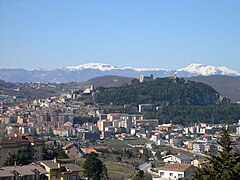 Overview of Campobasso.
 -

-

-
 Monforte castle, Campobasso.
 -
 Matese mountain chain.


References[change | change source]
- ↑ "Presidente" (in Italian). Regione Molise. Retrieved 26 October 2017.
- ↑ 2.0 2.1 2.2 "Statistiche demografiche ISTAT" (in Italian). Demo.istat.it. Archived from the original on 3 January 2018. Retrieved 26 October 2017.
- ↑ EUROPA - Press Releases - Regional GDP per inhabitant in 2008 GDP per inhabitant ranged from 28% of the EU27 average in Severozapaden in Bulgaria to 343% in Inner London
- ↑ "Molise" (in Italian). Tuttitalia.it. Retrieved 26 October 2017.
- ↑ "La Meta-Anticima Orientale, Italy". Peakbagger.com. Retrieved 27 October 2017.
- ↑ "Comuni abruzzesi per popolazione" (in Italian). Tuttitalia.it. Retrieved 27 October 2017.
Other websites[change | change source]
- Official Site (in Italian)