Trenčín
Trenčín | |
|---|---|
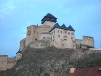
 Trenčín castle above the city | |
 Location of Trenčín within Slovakia | |
| Coordinates: 48°53′31″N 18°02′12″E / 48.89194°N 18.03667°E | |
| Country | Slovakia |
| Region (kraj) | Trenčín Region |
| Districts | Trenčín District |
| First mentioned | 1111 |
| Area | |
| • Total | 82.00 km2 (31.66 sq mi) |
| (2022) | |
| Elevation | 398 m (1,306 ft) |
| Population | |
| • Total | 54,107 |
| • Density | 660/km2 (1,700/sq mi) |
| Time zone | UTC+1 (CET) |
| • Summer (DST) | UTC+2 (CEST) |
| Postal Code | 91101 |
| Website | www.trencin.sk |
Trenčín (German: Trentschin; Hungarian: Trencsén; Latin: Laugaritio) is a town in western Slovakia (close to the Czech border) on the Váh river.
History[change | change source]
The site is inhabited since time immemorial. Trenčín is best known for Roman writing below the Trenčín castle. In the 13th century, the castle was home to the legendary Matthew Csák, "Lord of the river Váh and the Tatra mountains".
Partner towns[change | change source]
 Cran-Gevrier, France
 Uherské Hradiště, Czech Republic
 Zlín, Czech Republic
 Tarnów, Poland
 Casalecchio di Reno, Italy
 Békéscsaba, Hungary
 Kragujevac, Serbia
References[change | change source]
- ↑ Statistical Office of the Slovak Republic (www.statistics.sk). "Hustota obyvateľstva - obce". www.statistics.sk. Retrieved 2024-02-08.
- ↑ Statistical Office of the Slovak Republic (www.statistics.sk). "Počet obyvateľov podľa pohlavia - obce (ročne)". www.statistics.sk. Retrieved 2024-02-08.
Other websites[change | change source]
Wikimedia Commons has media related to Trenčín.


