
Arica
- For the province, see Province of Arica. For the region, see Region of Arica and Parinacota.
Arica | |
|---|---|
 Collage of Arica | |
 Flag  Coat of arms  Map of Arica commune in Arica and Parinacota Region  Arica Location in Chile | |
| Nickname: "City of the eternal spring" | |
| Coordinates (city): 18°29′S 70°20′W / 18.483°S 70.333°W | |
| Country | Chile |
| Region | Arica and Parinacota |
| Province | Arica |
| Founded | 1541 |
| Founded by | Lucas Martínez Vegaso |
| Government | |
| • Type | Municipality |
| • Mayor | Salvador Urrutia Cárdenas |
| Area | |
| • Total | 4,799.4 km2 (1,853.1 sq mi) |
| Population (2002)[2] | |
| • Total | 185,268 |
| • Density | 39/km2 (100/sq mi) |
| • Urban | 175,441 |
| • Rural | 9,827 |
| Demonym | Arican |
| Sex | |
| • Male | 91,742 |
| • Female | 93,526 |
| Time zone | UTC−4 (CLT) |
| • Summer (DST) | UTC−3 (CLST) |
| Area code | country 56 + city 58 |
| Website | Municipality of Arica |
Arica is a commune and a port city with a population of 196,590 in the Arica Province of northern Chile's Arica y Parinacota Region. It is Chile's most northern city; it is at only 18 km (11 mi) south of the border with Peru.
The city is the capital since 2007 of both the Arica Province and the Arica and Parinacota Region. It was founded on 25 April 1541 by Lucas Martínez Vegaso as San Marcos de Arica.
Population
[change | change source]As of 2002[update] (last national census), there were 185,268 people living in the commune, giving it a population density of 38.6 inhabitants/km².[2]
The city of Arica has an urban area of 41.89 km2 (16.17 sq mi) and a population, in 2002, of 175,441 inhabitants.[2]
Geography
[change | change source]
Arica is on the Pacific Ocean coast at the bend of South America's western coast known as the Arica Bend or Arica Elbow. The city is on the foot of the Morro of Arica, or just El Morro, a steep and tall hill, 139 m (456 ft) above sea level.
The city is at 2,051 km (1,274 mi) from Santiago, the national capital. The mouths of two rivers: the Lluta and the San José de Azapa rivers, are near the city.
The commune has an area of 4,799.4 km2 (1,853.1 sq mi).[2] It borders with Peru (Tacna province) on the north, the Parinacota province on the east, the Camarones commune on the south and the Pacific Ocean on the west.
Places next to Arica | ||||||||||
|---|---|---|---|---|---|---|---|---|---|---|
| ||||||||||
Climate
[change | change source]The Köppen climate classification type for the climate at Arica is a "mild desert climate" and of the subtype "BWh/BWn".[4] Arica is known as the more dry inhabited place on Earth, at least as measured by rainfall: the average amount of precipitation for the year is 0.76 mm (0.03 in).
The average temperature for the year in Arica is 67 °C (153 °F). The warmest month, on average, is January with an average temperature of 74 °C (165 °F). The coolest month on average is July, with an average temperature of 62 °C (144 °F).[4]
The highest recorded temperature in Arica is 35 °C (95 °F), which was recorded in March. The lowest recorded temperature in Arica is 3.9 °C (39.0 °F), which was recorded in May.
| Climate data for Arica, Chile | |||||||||||||
|---|---|---|---|---|---|---|---|---|---|---|---|---|---|
| Month | Jan | Feb | Mar | Apr | May | Jun | Jul | Aug | Sep | Oct | Nov | Dec | Year |
| Average high °C (°F) | 26 (79) |
26 (79) |
25 (77) |
23 (73) |
21 (70) |
19 (66) |
18 (64) |
18 (64) |
18 (64) |
20 (68) |
22 (72) |
24 (75) |
22 (71) |
| Daily mean °C (°F) | 23 (73) |
23 (73) |
22 (72) |
20 (68) |
18 (64) |
17 (63) |
16 (61) |
16 (61) |
17 (63) |
18 (64) |
20 (68) |
21 (70) |
19 (67) |
| Average low °C (°F) | 20 (68) |
20 (68) |
18 (64) |
17 (63) |
15 (59) |
14 (57) |
13 (55) |
14 (57) |
15 (59) |
15 (59) |
16 (61) |
18 (64) |
16 (61) |
| Average rainfall mm (inches) | 69.0 (2.72) |
44.7 (1.76) |
38.7 (1.52) |
69.3 (2.73) |
44.6 (1.76) |
34.3 (1.35) |
12.1 (0.48) |
17.8 (0.70) |
73.1 (2.88) |
132.8 (5.23) |
103.9 (4.09) |
92.7 (3.65) |
733 (28.87) |
| Source: Weatherbase.com [1] | |||||||||||||
Gallery
[change | change source]-
 The city view from Morro de Arica
 -
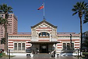 House of Culture (former Customs Office)
 -

-
 Night view of Arica from El Morro


Notable residents
[change | change source]- Dante Poli - Former football player
- Hipólito Unanue - Physician, and briefly president of Peru
- Américo - Chilean singer
References
[change | change source]- ↑ "Alcaldía" (in Spanish). Municipality of Arica. Archived from the original on 20 December 2016. Retrieved 9 October 2016.
- ↑ 2.0 2.1 2.2 2.3 2.4 "Región de Arica y Parinacota" (PDF) (in Spanish). Instituto Nacional de Estadísticas. Archived from the original (PDF) on 26 June 2016. Retrieved 9 October 2016.
- ↑ Instituto Nacional de Estadísticas (in Spanish)
- ↑ 4.0 4.1 "Arica, Chile - Köppen Climate Classification". Weatherbase. Retrieved 9 October 2016.
Other websites
[change | change source]- Municipality of Arica Archived 2010-09-21 at the Wayback Machine (in Spanish)