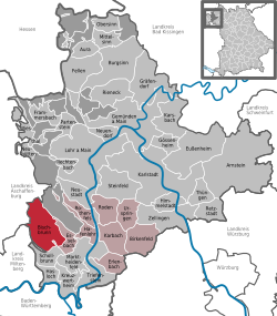
Bischbrunn
Bischbrunn | |
|---|---|
| Coordinates: 49°52′13″N 09°29′21″E / 49.87028°N 9.48917°E | |
| Country | Germany |
| State | Bavaria |
| Admin. region | Unterfranken |
| District | Main-Spessart |
| Municipal assoc. | Marktheidenfeld |
| Government | |
| • Mayor (2020–26) | Agnes Engelhardt[1] |
| Area | |
| • Total | 36.18 km2 (13.97 sq mi) |
| Elevation | 395 m (1,296 ft) |
| Population (2022-12-31)[2] | |
| • Total | 1,821 |
| • Density | 50/km2 (130/sq mi) |
| Time zone | UTC+01:00 (CET) |
| • Summer (DST) | UTC+02:00 (CEST) |
| Postal codes | 97836, 97852 (Schleifmühle) |
| Dialling codes | 09394 |
| Vehicle registration | MSP |
| Website | www |
Bischbrunn is a community with around 1,800 (2013) residents in Main-Spessart in the Regierungsbezirk of Lower Franconia (Unterfranken) in Bavaria, Germany and a member of the Verwaltungsgemeinschaft (Administrative Community) of Marktheidenfeld.
Geography[change | change source]
Location[change | change source]
Bischbrunn is in Main-Spessart, in the Würzburg Region. It is in the Spessart range of hills. The Geiersberg, the highest elevation in the Spessart is in the municipal territory.
The community has the following Gemarkungen (traditional rural cadastral areas): Bischbrunn, Bischbrunner Forst, Fürstlich Löwenstein'scher Park, Oberndorf.
References[change | change source]
- ↑ Liste der ersten Bürgermeister/Oberbürgermeister in kreisangehörigen Gemeinden, Bayerisches Landesamt für Statistik, 15 July 2021.
- ↑ Genesis Online-Datenbank des Bayerischen Landesamtes für Statistik Tabelle 12411-003r Fortschreibung des Bevölkerungsstandes: Gemeinden, Stichtag (Einwohnerzahlen auf Grundlage des Zensus 2011)
Other websites[change | change source]
Wikimedia Commons has media related to Bischbrunn.


