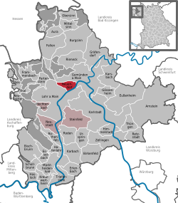
Neuendorf, Bavaria
Neuendorf | |
|---|---|
| Coordinates: 50°1′57″N 9°38′38″E / 50.03250°N 9.64389°E | |
| Country | Germany |
| State | Bavaria |
| Admin. region | Unterfranken |
| District | Main-Spessart |
| Municipal assoc. | Lohr am Main |
| Government | |
| • Mayor (2020–26) | Karlheinz Albert[1] |
| Area | |
| • Total | 9.65 km2 (3.73 sq mi) |
| Elevation | 156 m (512 ft) |
| Population (2022-12-31)[2] | |
| • Total | 822 |
| • Density | 85/km2 (220/sq mi) |
| Time zone | UTC+01:00 (CET) |
| • Summer (DST) | UTC+02:00 (CEST) |
| Postal codes | 97788 |
| Dialling codes | 09351 |
| Vehicle registration | MSP |
| Website | www.neuendorf-main.de |
Neuendorf is a community in Main-Spessart in the Regierungsbezirk of Lower Franconia (Unterfranken) in Bavaria, Germany and a member of the Verwaltungsgemeinschaft (Administrative Community) of Lohr am Main.
Geography[change | change source]
Location[change | change source]
Neuendorf is in the Würzburg Region in the Vorspessart, and is bounded on the south by the river Main. It is between the towns of Gemünden am Main and Lohr.
Constituent communities and Gemarkungen[change | change source]
The community has only the Gemarkung (traditional rural cadastral area) of Neuendorf; however, it is made up of two Ortsteile called Neuendorf and Nantenbach.
Sources[change | change source]
References[change | change source]
- ↑ Liste der ersten Bürgermeister/Oberbürgermeister in kreisangehörigen Gemeinden, Bayerisches Landesamt für Statistik, 15 July 2021.
- ↑ Genesis Online-Datenbank des Bayerischen Landesamtes für Statistik Tabelle 12411-003r Fortschreibung des Bevölkerungsstandes: Gemeinden, Stichtag (Einwohnerzahlen auf Grundlage des Zensus 2011)
Other websites[change | change source]
Wikimedia Commons has media related to Neuendorf (Unterfranken).
- Official website
 (in German)
 - Verwaltungsgemeinschaft (Administrative Community) of Lohr am Main (in German)
- Schönrain ruins (in German)


