Claremont, New Hampshire
Claremont, New Hampshire | |
|---|---|
 City Hall | |
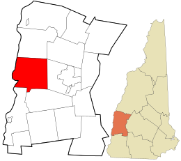
 Location in Sullivan County and the state of New Hampshire | |
| Coordinates: 43°22′20″N 72°20′15″W / 43.37222°N 72.33750°W | |
| Country | United States |
| State | New Hampshire |
| County | Sullivan |
| Settled | 1762[1] |
| Incorporated | 1764 (town), 1947 (city) |
| Villages |
|
| Area | |
| • Total | 44.05 sq mi (114.09 km2) |
| • Land | 43.15 sq mi (111.77 km2) |
| • Water | 0.90 sq mi (2.32 km2) 2.04% |
| Elevation | 551 ft (168 m) |
| Population (2020) | |
| • Total | 12,949 |
| • Density | 300.07/sq mi (115.86/km2) |
| Time zone | UTC−5 (EST) |
| • Summer (DST) | UTC−4 (EDT) |
| ZIP code | 03743 |
| Area code | 603 |
| FIPS code | 33-12900 |
| GNIS feature ID | 866173[3] |
| Website | www |
Claremont is the only city in Sullivan County, New Hampshire, United States. The population was 12,949 at the 2020 census.[4]
References[change | change source]
- ↑ "Area History". City of Claremont official website. Archived from the original on July 9, 2015. Retrieved July 20, 2015.
- ↑ "ArcGIS REST Services Directory". United States Census Bureau. Retrieved September 20, 2022.
- ↑ U.S. Geological Survey Geographic Names Information System: Claremont
- ↑ "QuickFacts: Claremont city, New Hampshire". United States Census Bureau. Retrieved February 5, 2024.


