Division of Watson
| Watson Australian House of Representatives Division | |
|---|---|
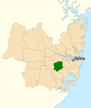
 Division of Watson (green) in New South Wales | |
| Created | 1992 |
| MP | Tony Burke |
| Party | Labor |
| Namesake | Chris Watson |
| Electors | 101,329 (2013)[1] |
| Area | 42 km2 (16.2 sq mi) |
| Demographic | Inner Metropolitan |

The Division of Watson is an Australian electoral division in the state of New South Wales. It was set up for the 1993 election to replace the abolished Division of St George. It is named after Chris Watson, the first Labor Prime Minister of Australia.[2]
The division is located in the southern suburbs of Sydney, including Belfield, Belmore, Burwood Heights, Campsie, Chullora, Clemton Park, Enfield, Greenacre, Lakemba, Mount Lewis, Roselands, Strathfield South and Wiley Park and parts of Ashbury, Bankstown, Beverly Hills, Burwood, Canterbury, Croydon, Croydon Park, Earlwood, Kingsgrove, Narwee, Punchbowl, Riverwood and Strathfield.[2]
History[change | change source]
There was an earlier Division of Watson (1934-69). It was in the south-eastern suburbs of Sydney, however that Division is not connected to this one except in name.
Members[change | change source]
| Member | Party | Term | |
|---|---|---|---|
| Leo McLeay | Labor | 1993–2004 | |
| Tony Burke | Labor | 2004–present | |
Leo McLeay was Speaker of the Australian House of Representatives.
Election results[change | change source]
| 2022 Australian federal election: Watson[3] | |||||
|---|---|---|---|---|---|
| Party | Candidate | Votes | % | ±% | |
| Labor | Tony Burke | 44,464 | 51.87 | +0.18 | |
| Liberal | Sazeda Akter | 22,759 | 26.55 | −2.85 | |
| Greens | Bradley Schott | 8,200 | 9.57 | +2.47 | |
| United Australia | John Koukoulis | 6,126 | 7.15 | +2.94 | |
| One Nation | Alan Jorgensen | 4,178 | 4.87 | +4.87 | |
| Total formal votes | 85,727 | 90.27 | +2.88 | ||
| Informal votes | 9,245 | 9.73 | −2.88 | ||
| Turnout | 94,972 | 87.36 | −2.09 | ||
| Two-party-preferred result | |||||
| Labor | Tony Burke | 55,810 | 65.10 | +1.58 | |
| Liberal | Sazeda Akter | 29,917 | 34.90 | −1.58 | |
| Labor hold | Swing | +1.58 | |||
References[change | change source]
- ↑ "NSW Division - Watson, NSW". Virtual Tally Room, Election 2013. Australian Electoral Commission. 27 September 2013. Archived from the original on 2 November 2013. Retrieved 6 November 2013.
- ↑ 2.0 2.1 "Profile of the electoral division of Watson (NSW)". Australian Electoral Commission. 2014. Retrieved 19 January 2014.
- ↑ Watson, NSW, 2022 Tally Room, Australian Electoral Commission.
