Greenlee County, Arizona
Greenlee County | |
|---|---|
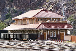
 1901 Clifton railroad station, now used by the Chamber of Commerce and other community organizations | |
 Location within the U.S. state of Arizona | |
 Arizona's location within the U.S. | |
| Coordinates: 33°06′06″N 109°16′07″W / 33.1017°N 109.2686°W | |
| Country | |
| State | |
| Founded | March 10, 1909 |
| Named for | Mason Greenlee |
| Seat | Clifton |
| Largest town | Clifton |
| Area | |
| • Total | 1,848 sq mi (4,790 km2) |
| • Land | 1,843 sq mi (4,770 km2) |
| • Water | 5.3 sq mi (14 km2) 0.3% |
| Population | |
| • Total | 9,563 |
| • Density | 5.2/sq mi (2.0/km2) |
| Time zone | UTC−7 (Mountain) |
| Website | www |

Greenlee County is a county found in the southeastern part of the U.S. state of Arizona. As of the 2020 census its population was 9,563,[1] making it the least populous county in Arizona. The county seat is Clifton.
History[change | change source]
The county was founded in 1909. The land was taken from nearby Graham County. It was named for Mason Greenlee. He was an early settler in the area. It was Arizona's 14th conty.
Other websites[change | change source]
www
References[change | change source]
- ↑ 1.0 1.1 "QuickFacts: Greenlee County, Arizona". United States Census Bureau. Retrieved August 8, 2023.

