
List of cities in Ontario
A city is a subtype of municipalities in the Canadian province of Ontario. A city can have the municipal status of either a single-tier or lower-tier municipality. Prior to 2003, Ontario had minimum population thresholds of 15,000 and 25,000 for city status. Minimum population thresholds are no longer necessary for a municipality to brand itself as a city.
List[change | change source]
-
 Toronto is Ontario's capital and Canada's largest city
 -
 Ottawa is Canada's capital and Ontario's second largest city
 -
 Downtown Brampton
 -
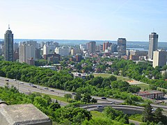 Skyline of downtown Hamilton
 -
 Skyline of downtown London
 -
 Richmond Hill Centre for the Performing Arts in Richmond Hill, Ontario's newest city
 -
 Vaughan as viewed from Canada's Wonderland
 -
 Downtown Kitchener
 -
 Downtown Windsor
 -
 Downtown Mississauga


.jpg)


| Name[1][2] | Municipal status[1] |
Census division[1][3] | Population (2016)[4] |
Population (2011)[2] |
Change (%)[2] |
Area (km²)[2] |
Population density[2] |
|---|---|---|---|---|---|---|---|
| Barrie[note 1] | Single-tier | Simcoe | 141,434 | 136,063 | 3.9 | 99.04 | 1,428.0 |
| Belleville | Single-tier | Hastings | 50,716 | 49,454 | 2.6 | 247.25 | 205.1 |
| Brampton | Lower-tier | Peel | 593,638 | 523,911 | 13.3 | 266.36 | 2,228.7 |
| Brant | Single-tier | Brant | 36,707 | 35,638 | 3.0 | 843.25 | 43.5 |
| Brantford[note 2] | Single-tier | Brant | 97,496 | 93,650 | 4.1 | 72.44 | 1,345.9 |
| Brockville | Single-tier | Leeds and Grenville | 21,346 | 21,870 | −2.4 | 20.85 | 1,023.6 |
| Burlington | Lower-tier | Halton | 183,314 | 175,779 | 4.3 | 185.66 | 987.3 |
| Cambridge[note 3] | Lower-tier | Waterloo | 129,920 | 126,748 | 2.5 | 113.01 | 1,149.6 |
| Clarence-Rockland | Lower-tier | Prescott and Russell | 24,512 | 23,185 | 5.7 | 297.71 | 82.3 |
| Cornwall | Single-tier | Stormont, Dundas and Glengarry | 46,589 | 46,340 | 0.5 | 61.56 | 756.8 |
| Chatham | Single-tier | Chatham | 43,550 | 44,676 | 2.3 | 2,451.9 | 756.8 |
| Dryden[note 4] | Single-tier | Kenora | 7,749 | 7,617 | 1.7 | 66.19 | 117.1 |
| Elliot Lake | Single-tier | Algoma | 10,741 | 11,348 | −5.3 | 714.65 | 15.0 |
| Greater Sudbury[note 5] | Single-tier | Sudbury | 161,531 | 160,274 | 0.8 | 3,228.35 | 50.0 |
| Guelph | Single-tier | Wellington | 131,794 | 121,688 | 8.3 | 87.22 | 1,511.1 |
| Haldimand County | Single-tier | Haldimand | 45,608 | 44,876 | 1.6 | 1,251.54 | 36.4 |
| Hamilton[note 6] | Single-tier | Hamilton | 536,917 | 519,949 | 3.3 | 1,117.29 | 480.6 |
| Kawartha Lakes | Single-tier | Kawartha Lakes | 75,423 | 73,214 | 3.0 | 3,084.38 | 24.5 |
| Kenora | Single-tier | Kenora | 15,096 | 15,348 | −1.6 | 211.59 | 71.3 |
| Kingston | Single-tier | Frontenac | 123,798 | 123,363 | 0.4 | 451.19 | 274.4 |
| Kitchener[note 7] | Lower-tier | Waterloo | 233,222 | 219,153 | 6.4 | 136.77 | 1,705.2 |
| London[note 8] | Single-tier | Middlesex | 383,822 | 366,151 | 4.8 | 420.35 | 913.1 |
| Leamington | Single-tier | Essex | 27,595 | 28,403 | 0.58 | 261.24 | 105.3 |
| Markham | Lower-tier | York | 328,966 | 301,709 | 9.0 | 212.35 | 1,549.2 |
| Mississauga[note 9] | Lower-tier | Peel | 721,599 | 713,443 | 1.1 | 292.43 | 2,467.6 |
| Niagara Falls[note 10] | Lower-tier | Niagara | 88,071 | 82,997 | 6.1 | 209.73 | 419.9 |
| Norfolk County | Single-tier | Norfolk | 64,044 | 63,175 | 1.4 | 1,607.55 | 39.8 |
| North Bay | Single-tier | Nipissing | 51,553 | 53,651 | −3.9 | 319.11 | 161.6 |
| Orillia | Single-tier | Simcoe | 31,166 | 30,586 | 1.9 | 28.58 | 1,090.3 |
| Oshawa[note 11] | Lower-tier | Durham | 159,458 | 149,607 | 6.6 | 145.64 | 1,094.9 |
| Ottawa[note 12] | Single-tier | Ottawa | 934,243 | 883,391 | 5.8 | 2,790.30 | 334.8 |
| Owen Sound | Lower-tier | Grey | 21,341 | 21,688 | −1.6 | 24.27 | 879.2 |
| Pembroke[note 13] | Single-tier | Renfrew | 13,882 | 14,360 | −3.3 | 14.56 | 953.3 |
| Peterborough[note 14] | Single-tier | Peterborough | 81,032 | 78,698 | 2.9 | 64.25 | 1,261.2 |
| Pickering | Lower-tier | Durham | 91,771 | 88,721 | 3.4 | 231.55 | 396.3 |
| Port Colborne | Lower-tier | Niagara | 18,306 | 18,424 | −0.6 | 121.96 | 150.1 |
| Prince Edward County | Single-tier | Prince Edward | 24,735 | 25,258 | −2.1 | 1,050.49 | 23.5 |
| Quinte West | Single-tier | Hastings | 43,577 | 43,086 | 1.1 | 494.02 | 88.2 |
| Richmond Hill[note 15] | Lower-tier | York | 195,022 | 185,541 | 5.1 | 101.11 | 1,928.8 |
| Sarnia | Lower-tier | Lambton | 71,594 | 72,366 | −1.1 | 164.85 | 434.3 |
| Sault Ste. Marie | Single-tier | Algoma | 73,368 | 75,141 | −2.4 | 223.24 | 328.6 |
| St. Catharines[note 16] | Lower-tier | Niagara | 133,113 | 131,400 | 1.3 | 96.13 | 1,384.8 |
| St. Thomas | Single-tier | Elgin | 38,909 | 37,905 | 2.6 | 35.63 | 1,092.1 |
| Stratford | Single-tier | Perth | 31,465 | 30,886 | 1.8 | 28.28 | 1,112.5 |
| Temiskaming Shores | Single-tier | Timiskaming | 9,920 | 10,400 | −4.6 | 178.11 | 55.7 |
| Thorold | Lower-tier | Niagara | 18,801 | 17,931 | 4.9 | 82.99 | 226.5 |
| Thunder Bay[note 17] | Single-tier | Thunder Bay | 107,909 | 108,359 | −0.4 | 328.36 | 328.6 |
| Timmins | Single-tier | Cochrane | 41,788 | 43,165 | −3.2 | 2,978.83 | 14.0 |
| Toronto[note 18] | Single-tier | Toronto | 2,731,571 | 2,615,060 | 4.5 | 630.20 | 4,334.4 |
| Vaughan | Lower-tier | York | 306,233 | 288,301 | 6.2 | 273.56 | 1,119.4 |
| Waterloo[note 19] | Lower-tier | Waterloo | 104,986 | 98,780 | 6.3 | 64.02 | 1,639.8 |
| Welland | Lower-tier | Niagara | 52,293 | 50,631 | 3.3 | 81.04 | 645.3 |
| Windsor[note 20] | Single-tier | Essex | 217,188 | 210,891 | 3.0 | 146.38 | 1,483.8 |
| Woodstock | Lower-tier | Oxford | 40,902 | 37,754 | 8.3 | 48.97 | 835.3 |
| Total cities | — | — | 9,900,179 | 9,478,924 | 2.39 | 26,045.14 | 813.91 |
Related pages[change | change source]
Notes[change | change source]
- ↑ The Barrie census metropolitan area (CMA) is formed around the City of Barrie.
- ↑ The Brantford CMA includes the City of Brantford as well as the County of Brant, which is a single-tier city.
- ↑ The City of Cambridge, as well as the cities of Kitchener and Waterloo, form parts of the Kitchener–Cambridge–Waterloo CMA.
- ↑ Dryden is Ontario's smallest city by population.
- ↑ Greater Sudbury is Ontario's largest city by area. The Greater Sudbury CMA is formed around the City of Greater Sudbury.
- ↑ Hamilton is Canada's tenth-largest city. The Hamilton CMA includes the cities of Burlington and Hamilton.
- ↑ The City of Kitchener, as well as the cities of Cambridge and Waterloo, form parts of the Kitchener–Cambridge–Waterloo CMA.
- ↑ The London CMA includes the cities of London and St. Thomas.
- ↑ Mississauga is Ontario's largest lower-tier city.
- ↑ The City of Niagara Falls, as well as the cities of Port Colborne, St. Catharines, Thorold and Welland, form parts of the St. Catharines–Niagara CMA.
- ↑ The Oshawa CMA is formed around the City of Oshawa.
- ↑ Ottawa is Canada's capital and fourth-largest city. The Ontario portion of the Ottawa–Gatineau CMA includes the cities of Clarence-Rockland and Ottawa.
- ↑ Pembroke is Ontario's smallest city by area.
- ↑ The Peterborough CMA is formed around the City of Peterborough.
- ↑ Richmond Hill is Ontario's newest city, adopting the name on March 26, 2019.
- ↑ The City of St. Catharines, as well as the cities of Niagara Falls, Port Colborne, Thorold and Welland, form parts of the St. Catharines–Niagara CMA.
- ↑ The Thunder Bay CMA is formed around the City of Thunder Bay.
- ↑ Toronto is Ontario's capital and Canada's and Ontario's largest city by population. The Toronto CMA includes the cities of Brampton, Markham, Mississauga, Pickering, Richmond Hill, Toronto and Vaughan.
- ↑ The City of Waterloo, as well as the cities of Cambridge and Kitchener, form parts of the Kitchener–Cambridge–Waterloo CMA.
- ↑ The Windsor CMA is formed around the City of Windsor.
References[change | change source]
- ↑ 1.0 1.1 1.2 "List of Ontario Municipalities". Ontario Municipal Affairs and Housing. September 21, 2012. Archived from the original on February 28, 2013. Retrieved January 3, 2013.
- ↑ 2.0 2.1 2.2 2.3 2.4 "Population and dwelling counts, for Canada, provinces and territories, and census subdivisions (municipalities), 2011 and 2006 censuses (Ontario)". Statistics Canada. May 28, 2012. Retrieved January 3, 2013.
- ↑ "Population and dwelling counts, for Canada, provinces and territories, and census divisions, 2011 and 2006 censuses (Ontario)". Statistics Canada. January 30, 2013. Retrieved June 27, 2013.
- ↑ "subdivisions (municipalities) and designated places, 2016 and 2011 censuses – 100% data". Statistics Canada. 8 February 2017.
Subdivisions of Ontario | |
|---|---|
| Counties | |
| Districts | |
| Regional municipalities | |
| Single-tier municipalities | |
| Separated municipalities | |
| Regions | |
| Provinces | |
|---|---|
| Territories | |