Prince Edward County, Ontario
Prince Edward | |
|---|---|
| County of Prince Edward | |
 | |
| Coordinates: 44°00′N 77°15′W / 44.000°N 77.250°W | |
| Country | Canada |
| Province | Ontario |
| County | none (Single-tier municipality) |
| Settled | 1792 |
| Incorporated | 1998 |
| Government | |
| • Type | City |
| • Mayor | Robert Leighton Quaiff |
| • Federal riding | Prince Edward—Hastings |
| • Prov. riding | Prince Edward—Hastings |
| Area | |
| • Land | 1,050.45 km2 (405.58 sq mi) |
| Population (2011)[1] | |
| • Total | 25,258 |
| • Density | 24.0/km2 (62/sq mi) |
| Time zone | UTC-5 (EST) |
| • Summer (DST) | UTC-4 (EDT) |
| Postal Code | K0K |
| Area code | 613 |
| Website | www.pecounty.on.ca |
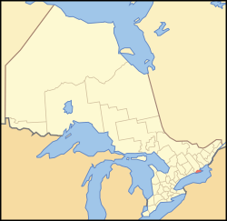
Prince Edward County is a county in Ontario, Canada. It is in Southern Ontario near the eastern end of Lake Ontario. The Bay of Quinte is north and east of the county. The county covers 1,050.45 square kilometers (405.58 square miles). According to the 2011 census, the county had a population of 25,258.
Prince Edward County is a single-tier municipality, which means it is not divided into townships and cities. There are several unincorporated communities in the county, including Picton, where the county government is based.
The Picton Pirates of the Empire B Junior C Hockey League play in Piction. The Wellington Dukes of the Ontario Junior Hockey League play in Wellington.
Prince Edward County is popular with tourists. Because it is on a lake, water sports like canoeing and sailing are very popular. The Sandbanks Provincial Park is near Picton; it is the world's largest fresh water sand bar and dune system.
References[change | change source]
- ↑ 1.0 1.1 "Prince Edward County census profile". 2011 Census of Population. Statistics Canada. Archived from the original on 2017-08-22. Retrieved 2012-02-28.
