
Llanymynech
| Llanymynech | |
|---|---|
 The Montgomery Canal passing through Llanymynech | |
 Llanymynech | |
| Location within Shropshire | |
| Population | 1,675 (2011) |
| OS grid reference | SJ266209 |
| Civil parish | |
| Unitary authority | |
| Ceremonial county | |
| Region | |
| Country | England |
| Sovereign state | United Kingdom |
| Post town | LLANYMYNECH |
| Postcode district | SY22 |
| Dialling code | 01691 |
| Police | West Mercia |
| Fire | Shropshire |
| Ambulance | West Midlands |
| UK Parliament | |
Llanymynech is a village in Shropshire, England and Powys, Wales. It is in the civil parish of Llanymynech and Pant, next to the River Vyrnwy.
It is located 17.4 miles north-west of Shrewsbury, Shropshire's county town and 9 miles (14 km) north of the Welsh town of Welshpool. It straddles the Welsh border. Some parts of the village, such as the golf course, are located in Wales. Two of the village's three pubs are entirely in England and the third is entirely in Wales.
The village's name is "Church of the Monks" in Welsh.
Shortly to the north of the village is the village of Pant. Further north is the market town of Oswestry.
The village has an amateur football club, Llanymynech FC.
Gallery[change | change source]
-
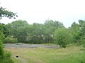 Former goods yard at Llanymynech
 -
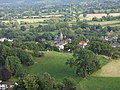 Llanymynech viewed from Llanymynech Hill
 -
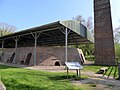 Hoffmann Kiln


