Loogootee, Indiana
Loogootee, Indiana | |
|---|---|
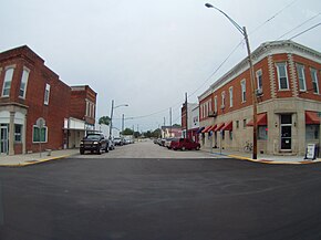
 Looking down West Main Street from U.S. 231 | |
 Location in Martin County, Indiana | |
| Coordinates: 38°40′32″N 86°54′51″W / 38.67556°N 86.91417°W | |
| Country | United States |
| State | Indiana |
| County | Martin |
| Township | Perry |
| Area | |
| • Total | 1.57 sq mi (4.06 km2) |
| • Land | 1.56 sq mi (4.05 km2) |
| • Water | 0.00 sq mi (0.01 km2) 0% |
| Elevation | 532 ft (162 m) |
| Population | |
| • Total | 2,601 |
| • Density | 1,661.98/sq mi (641.74/km2) |
| Time zone | UTC-5 (Eastern (EST)) |
| • Summer (DST) | UTC-4 (EDT) |
| ZIP code | 47553 |
| Area code(s) | 812 and 930 |
| FIPS code | 18-44910[4] |
| GNIS feature ID | 2395763[2] |
| Website | loogootee |
Loogootee is a city of Martin County in the state of Indiana, United States.
References[change | change source]
- ↑ "2022 U.S. Gazetteer Files: Indiana". United States Census Bureau. Retrieved April 17, 2023.
- ↑ 2.0 2.1 U.S. Geological Survey Geographic Names Information System: Loogootee, Indiana
- ↑ "P1. Race – Loogootee city, Indiana: 2020 DEC Redistricting Data (PL 94-171)". U.S. Census Bureau. Retrieved April 17, 2023.
- ↑ "U.S. Census website". United States Census Bureau. Retrieved 2008-01-31.

