Lawrence, Indiana
Lawrence, Indiana | |
|---|---|
 | |
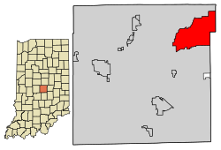
 Location in Marion County, Indiana | |
| Coordinates: 39°51′46″N 85°59′39″W / 39.86278°N 85.99417°W | |
| Country | United States |
| State | Indiana |
| County | Marion |
| Area | |
| • Total | 20.25 sq mi (52.43 km2) |
| • Land | 20.15 sq mi (52.18 km2) |
| • Water | 0.10 sq mi (0.25 km2) |
| Elevation | 873 ft (266 m) |
| Population | |
| • Total | 49,370 |
| • Density | 2,450.37/sq mi (946.11/km2) |
| Time zone | UTC-5 (EST) |
| • Summer (DST) | UTC-4 (EDT) |
| ZIP codes | 46216, 46226, 46235, 46236 |
| Area code(s) | 317, 463 |
| FIPS code | 18-42426[3] |
| GNIS feature ID | 0437666[4] |
| Website | www |
Lawrence is a city in the state of Indiana, in the United States.
References[change | change source]
- ↑ "2022 U.S. Gazetteer Files: Indiana". United States Census Bureau. Retrieved April 13, 2023.
- ↑ "P1. Race – Lawrence city, Indiana: 2020 DEC Redistricting Data (PL 94-171)". U.S. Census Bureau. Retrieved April 13, 2023.
- ↑ "US Census website". US Census Bureau. Retrieved 31 January 2008.
- ↑ "US Board on Geographic Names". USGS. 25 October 2007. Retrieved 31 January 2008.


