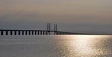
Oresund Bridge
Øresund Bridge Öresund Bridge | |
|---|---|
 | |
| Coordinates | 55°34′35″N 12°49′18″E / 55.57644°N 12.82164°E |
| Carries | Four lanes of European route E20 Double track Oresund Railway Line |
| Crosses | Oresund strait (The Sound) |
| Locale | Copenhagen, Denmark and Malmö, Sweden |
| Official name | Øresundsbroen, Öresundsbron |
| Characteristics | |
| Design | Cable-stayed bridge |
| Total length | 7,845 metres (25,738 ft) |
| Width | 23.5 metres (77.1 ft) |
| Longest span | 490 metres (1,608 ft) |
| Clearance below | 57 metres (187 ft) |
| History | |
| Designer | Georg Rotne |
| Engineering design by | Ove Arup & Partners Setec ISC Gimsing & Madsen |
| Constructed by | |
| Opened | July 1, 2000 |
| Statistics | |
| Daily traffic | ca. 17,000 road vehicles |
| Location | |
 | |
The Øresund Bridge (Danish: Øresundsbroen, Swedish: Öresundsbron, joint hybrid name: Øresundsbron) is a bridge and tunnel across the Øresund strait. It connects Denmark and Sweden.[1]
History[change | change source]
The construction of the Øresund Bridge began in 1995. When it was finished in 1999, Crown Prince Frederik of Denmark and Crown Princess Victoria of Sweden met in the middle.[2]
The official opening was on 1 July 2000. Queen Margrethe II and King Carl XVI Gustaf led the ceremonies together.[3]
Related pages[change | change source]
References[change | change source]
- ↑ Margolick, David. "Crossing The Oresund," New York Times. September 10, 2000; retrieved 2012-3-25.
- ↑ "Danmark og Sverige landfast" (in Danish), DR (Danish Broadcasting Corporation) (in Danish), 14 August 1999; retrieved 2012-3-25.
- ↑ "Øresundsbroen indviet" (in Danish), B.T./Ritzau, 1 July 2000; retrieved 2012-3-25.
Other websites[change | change source]
Wikimedia Commons has media related to Oresund bridge.
- Øresundsbron website (in English) Archived 2015-12-08 at the Wayback Machine
- Structurae, Øresund Bridge, Øresund Tunnel
- Road Traffic Technology, Øresund bridge project information
