
Pirmasens
Pirmasens | |
|---|---|
 Old town hall | |
 Coat of arms | |
Location of Pirmasens  | |
 Pirmasens  Pirmasens | |
| Coordinates: 49°12′N 7°36′E / 49.200°N 7.600°E | |
| Country | Germany |
| State | Rhineland-Palatinate |
| District | Urban district |
| Government | |
| • Lord mayor | Bernhard Matheis (CDU) |
| Area | |
| • Total | 61.37 km2 (23.70 sq mi) |
| Elevation | 380 m (1,250 ft) |
| Population (2021-12-31)[1] | |
| • Total | 40,054 |
| • Density | 650/km2 (1,700/sq mi) |
| Time zone | UTC+01:00 (CET) |
| • Summer (DST) | UTC+02:00 (CEST) |
| Postal codes | 66953–66955 |
| Dialling codes | 06331 |
| Vehicle registration | PS |
| Website | www.pirmasens.de |
Pirmasens (Palatine German: Bärmesens) is an independent town in Rhineland-Palatinate, Germany. It is near the border with France and was the center of the shoe industry in Germany until around 1970.
- Pirmasens
-
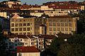 View with shoe factory
 -
 Shoe factory and city hall tower
 -
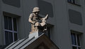 Shoemaker boy
 -
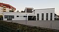
 Dynamikum
 -
 Old post office
 -
 New Apostolic Church
 -
 Listed residential building
 -
 Listed villa
 -
 Stairway of the birds
 -
 Stairway of the birds


References[change | change source]
Wikimedia Commons has media related to Pirmasens.