Strait of Hormuz


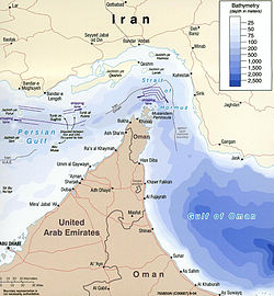
The Strait of Hormuz is a narrow, strategically important strait between the Gulf of Oman in the southeast and the Persian Gulf. On the north coast is Iran and on the south coast is the United Arab Emirates and Musandam, an exclave of Oman.
The strait at its narrowest is 21 nautical miles (39 km) wide.[1] Around 20% of the world's oil passes through the strait.[1]
Events[change | change source]
Operation Praying Mantis[change | change source]
Operation Praying Mantis was an attack on 18 April 1988 by the United States Armed Forces on Iranian boats in retaliation for the Iranian naval mining of international waters in the Persian Gulf during the Iran–Iraq War and the subsequent damage to an American warship.
The downing of Iran Air 655[change | change source]
On 3 July 1988, 290 people were killed when an Iran Air Airbus A300 passenger jet was shot down over the strait by the United States Navy guided missile cruiser USS Vincennes.
Collision between USS Newport News and tanker Mogamigawa[change | change source]
On 8 January 2007, the nuclear submarine USS Newport News, traveling submerged, hit M/V Mogamigawa, a 300,000-ton Japanese-flagged very large crude tanker, south of the strait.[2] There were no injuries, and no oil leaked from the tanker.
Tensions in 2008[change | change source]
[change | change source]
A series of naval stand-offs between Iranian speedboats and U.S. warships in the Strait of Hormuz occurred in December 2007 and January 2008. U.S. officials said Iran was harassing and provoking their naval vessels. Iranian officials said this was not true.
Iranian defence policy[change | change source]
On 29 June 2008, the commander of Iran's Revolutionary Guard, Ali Mohammed Safari, said that if Iran were attacked by Israel or the United States, it would close off the Strait of Hormuz. This would be bad for the oil markets. The US said that such an action by Iran would be an act of war. The U.S. would not allow this.[3]
[change | change source]
In the last week of July 2008, in the Operation Brimstone,[4] dozens of U.S. and foreign navy ships prepared for battle in the shallow waters off the coast of Iran.
As of 11 August 2008, more than 40 U.S. and allied ships were on the way to the Strait of Hormuz. There would be a total of five battle groups, not counting submarines.[5]
Collision between USS Hartford and USS New Orleans[change | change source]
On 20 March 2009, United States Navy Los Angeles-class submarine Hartford collided with the San Antonio-class amphibious transport dock New Orleans in the strait. The collision slightly injured 15 sailors aboard the Hartford. It opened a fuel tank aboard the New Orleans, spilling 25,000 US gallons (95 m3) of marine diesel fuel.[6]
Tensions in 2011–2012[change | change source]
On 27 December 2011, Iranian Vice President Mohammad-Reza Rahimi said Iran would stop oil supply from the Strait of Hormuz should Iran be limited in their oil exports.[7]
On 3 January 2012, Iran threatened to take action if the U.S. Navy moves an aircraft carrier back into the Persian Gulf.[8]
On 7 January 2012, the United Kingdom said that it would be sending the Type 45 destroyer HMS Daring to the Persian Gulf. Daring, which is the lead ship of her class is said to be one of the "most advanced warships" in the world. The ship will have its first mission in the Persian Gulf.[9] The British Government said that this move has been long-planned, as Daring will replace another Armilla patrol frigate.[10]
On 9 January 2012, Iranian Defense Minister Ahmad Vahidi said that Iran would not close the Strait of Hormuz.[11]
By 23 January, a flotilla was made by countries against Iran's threats to close the Hormuz Strait.[12] These ships were in the Persian Gulf and Arabian Sea off the coast of Iran.
References[change | change source]
- ↑ 1.0 1.1 "Strait of Hormuz". World Oil Transit Chokepoints. U.S. Energy Information Administration. 30 December 2011. Retrieved 14 January 2012.
- ↑ Dorsey, Jack (10 January 2007). "Navy says speed of tanker sucked submarine up to surface". The Virginian Pilot. Archived from the original on 16 October 2015. Retrieved 12 June 2012.
- ↑ "U.S. Navy Commander Warns Iran: Don't Try Closing Gulf Oil Passageway". Fox News. 2 July 2008.
- ↑ "JTFEX 08-4 "Operation Brimstone" Flexes Allied Force Training". US Navy. 15 July 2008. Archived from the original on 22 July 2008. Retrieved 12 June 2012.
- ↑ "Three major US naval strike forces due this week in Persian Gulf". Debkafile. 11 August 2008. Archived from the original on 1 December 2009. Retrieved 12 June 2012.
- ↑ "U.S. Navy vessels in Bahrain for evaluation after collision". CNN. 20 March 2009. Archived from the original on 13 January 2012. Retrieved 8 January 2012.
- ↑ "Oil jumps over 2% as Iran threatens supplies". CNN. 27 December 2011.
- ↑ Hafezi, Parisa (3 January 2012). "Iran threatens U.S. Navy as sanctions hit economy". Reuters. Archived from the original on 24 September 2015. Retrieved 8 January 2012.
- ↑ Harding, Thomas (6 January 2012). "Royal Navy sends its mightiest ship to take on the Iranian show of force in the Gulf". The Telegraph. London. Retrieved 8 January 2012.
- ↑ "HMS Daring to head for the Gulf". Press Association. 7 January 2012. Retrieved 8 January 2012.[permanent dead link]
- ↑ "Iran and the Strait of Hormuz". Tabeer. Archived from the original on 2013-07-29. Retrieved 2012-06-12.
- ↑ "Iran: Flotilla Of Warships Sent Through Strait of Hormuz Heightens Tensions". Huffington Post. 23 January 2012. Retrieved 24 January 2012.
Other websites[change | change source]
![]() Media related to Strait of Hormuz at Wikimedia Commons
Media related to Strait of Hormuz at Wikimedia Commons
